
How Do Drones Work in 2026? The Science and Technology Behind Flying Robots
Imagine standing in an empty field just after sunrise. The grass is wet, the air is almost still, and somewhere a small electronic beep announces that a battery has been connected.
Then the rotors begin to spin.
At first, the drone seems to tremble in place. A second later, it rises smoothly from the ground. It stops at eye level, holds its position against a light breeze, turns almost silently toward a distant tree, and begins moving forward.
From the ground, it can look almost magical.
But there is no magic inside that flying machine. There is a carefully coordinated conversation between electric motors, spinning propellers, sensors, computers, batteries, radio links, navigation systems and software. Hundreds or thousands of tiny decisions can happen every second.
A modern drone is therefore much more than a flying camera.
It is a small aircraft, a robotic control system, a communications device and, increasingly, a computer-vision platform.
That combination explains why drones have moved so quickly from hobbyist gadgets to tools used for filmmaking, agriculture, surveying, emergency response, scientific research, infrastructure inspection, mapping and delivery.
In 2026, some drones can hold their position with remarkable precision, follow programmed routes, recognize obstacles, create maps, track moving subjects and operate with increasingly sophisticated autonomy. Yet they remain subject to fundamental physics—and to practical limitations involving batteries, weather, sensors, communications and regulation.
So how does a drone actually work?

Key Takeaways
- A drone is an aircraft without a pilot physically onboard. The broader system includes the aircraft, payload, communications link, control software and human operator or supervisory system.
- Multirotor drones fly by changing the speed of their propellers. They do not need conventional wings to generate lift.
- Opposing propellers normally rotate in opposite directions. This lets the drone cancel unwanted rotational forces and control yaw.
- A flight controller is the drone's nervous system. It combines sensor information with pilot commands or autonomous instructions and continuously adjusts the motors.
- Gyroscopes and accelerometers help measure motion and orientation. Modern drones combine these with other sensors to estimate their position and attitude.
- GPS or other satellite-navigation systems provide geographic positioning, but GPS alone is not enough for stable flight.
- Cameras, optical-flow sensors, ultrasonic sensors, LiDAR and other systems can help a drone understand its surroundings.
- Obstacle avoidance is increasingly software-driven. Computer vision and machine-learning techniques can help identify objects, but they do not make a drone infallible.
- Battery technology remains one of the biggest constraints. Carrying more energy also means carrying more mass, creating a fundamental engineering trade-off.
- The future of drones is increasingly autonomous, but autonomy does not mean unlimited independence. Safety, communications, airspace management and regulations remain essential.
1. What Exactly Is a Drone?
The word "drone" is convenient, but technically broad.
A drone is generally an aircraft that operates without a human pilot sitting inside it. Aviation authorities and engineers often use terms such as uncrewed aircraft system (UAS) or unmanned aircraft system.
The word "system" matters.
A drone is not simply the aircraft.
NASA describes a UAS as a system that can include the aircraft itself, its payload, communications or data link, command-and-control equipment, support equipment and the human element responsible for operating it.
That means a camera drone is really a collection of interconnected systems.
There is the physical aircraft. There are the motors and propellers. There is a battery. There are electronic speed controllers. There is a flight computer. There are sensors. There may be several cameras. There is a radio connection to a controller. There may be satellite navigation. And there is software coordinating all of it.
A large agricultural drone can be built very differently from a tiny indoor drone, while a fixed-wing mapping drone can look more like a miniature airplane than a quadcopter.
The common idea is not a particular shape.
It is the absence of an onboard pilot.
2. The Four-Propeller Drone: The Most Familiar Design
When many people picture a drone, they imagine a quadcopter: four arms, four motors and four propellers.
The quadcopter became popular because its design is mechanically simple compared with a conventional helicopter.
A helicopter generally needs a complex main rotor system and a method for controlling the torque produced by that rotor.
A quadcopter can distribute the work among four smaller propellers.
Two normally rotate clockwise and two counterclockwise.
This arrangement is extremely important.
If every propeller rotated in the same direction, the body of the drone would experience a strong reaction torque in the opposite direction. The aircraft would tend to spin.
By using opposing pairs, much of that torque can cancel out.
The drone can then deliberately change the balance between the motors to control its movement.
This is one of the elegant features of multirotor flight: there are no conventional ailerons, elevators or rudders required for the basic movements of a quadcopter.
The motors themselves become the control surfaces.
3. How Does a Drone Fly?
The simplest answer is:
Its propellers push air downward, producing an upward force.
A propeller is essentially a rotating aerodynamic surface. As it spins, it accelerates air downward. The resulting change in momentum produces an upward reaction force on the drone.
If the total upward thrust is approximately equal to the drone's weight, the drone can hover.
If thrust becomes greater than weight, the drone accelerates upward.
If thrust becomes lower than weight, it descends.
This sounds simple, but controlling that relationship continuously is surprisingly demanding.
Imagine trying to balance a pencil vertically on your fingertip.
You would constantly make tiny corrections. The pencil starts leaning one way, so you move your finger. Then it leans the other way, so you compensate again.
A drone does something conceptually similar.
Except it does not have a human brain making those corrections.
Its flight controller performs them electronically, many times per second.
4. How a Drone Moves Forward
A quadcopter does not normally fly forward by simply pointing its propellers forward.
Instead, it tilts.
Suppose the drone is hovering perfectly level.
The motors are producing enough thrust to counteract gravity.
Now the flight controller slightly increases or decreases thrust between different motors so that the aircraft pitches forward.
The total thrust vector is now tilted.
Part of that thrust continues to oppose gravity.
The other part points forward.
The drone therefore accelerates forward.
The same principle works backward and sideways.
Tilt forward: move forward.
Tilt backward: move backward.
Roll right: move right.
Roll left: move left.
The drone can then return to level orientation and reduce its horizontal acceleration.
This is why a drone moving quickly can look tilted even though its camera may remain stabilized.
5. Pitch, Roll and Yaw
Three words appear repeatedly in aviation and robotics:
Pitch
Pitch is rotation around the aircraft's lateral axis.
For a quadcopter, pitching forward causes the drone to move forward.
Roll
Roll is rotation around the longitudinal axis.
Rolling to one side causes sideways movement.
Yaw
Yaw is rotation around the vertical axis.
Yaw turns the drone left or right without necessarily changing its horizontal position.
The flight controller can manipulate these movements by changing individual motor speeds.
For example, to pitch forward, it can increase thrust at the rear motors and/or reduce thrust at the front motors.
To roll right, it can alter the relative thrust of the left and right motors.
To yaw, it changes the balance between clockwise and counterclockwise rotating propellers.
The important point is that the pilot does not need to calculate these motor speeds manually.
The controller translates a simple command such as "move forward" into hundreds of low-level adjustments.
6. The Flight Controller: The Drone's Nervous System
If the motors are the muscles of a drone, the flight controller is its nervous system.
It is a small computer, often equipped with specialized processors and sensors.
The flight controller receives information from:
- gyroscopes
- accelerometers
- magnetometers
- barometers
- satellite-navigation receivers
- optical sensors
- cameras
- distance sensors
- the remote controller
- onboard navigation software
It then calculates what the drone should do.
This process is continuous.
Imagine a person walking across a slippery floor. They do not consciously calculate every muscle contraction. Their nervous system constantly senses movement and adjusts muscles to maintain balance.
A drone's control system performs a machine equivalent.
If the drone tilts unexpectedly, the controller detects the change.
If wind pushes it sideways, the sensors detect the resulting movement.
The controller then modifies motor speeds to compensate.
The result is a machine that can appear almost motionless in the air even though its motors are constantly changing speed.
7. How Does a Drone Stay Stable?
This is one of the most impressive parts of modern drone technology.
A drone that is perfectly stable in still air is relatively easy to imagine.
Real air is not still.
There are gusts, turbulence, thermal currents and changes in wind direction. The drone's own propellers create airflow. The payload may shift the center of gravity. The battery becomes lighter in effective performance as its charge falls.
The drone must constantly respond.
Gyroscopes
A gyroscope measures rotational motion.
If the drone begins rotating or tilting, the gyroscope can detect the change.
Accelerometers
Accelerometers measure changes in acceleration.
Combined with gyroscope data, they help the flight controller estimate how the aircraft is moving.
Sensor fusion
No individual sensor is perfect.
A gyroscope can drift over time.
An accelerometer can be affected by vibration and movement.
A magnetic compass can be disturbed by electromagnetic interference or nearby metal.
Satellite navigation can become unreliable in certain environments.
So modern systems combine information from multiple sensors.
This is called sensor fusion.
The computer effectively asks:
"What do all these imperfect measurements tell me together?"
That combined estimate is far more useful than relying on a single sensor.
8. What Is GPS Doing Inside a Drone?
Satellite navigation is one of the technologies that transformed consumer drones.
A navigation receiver can use signals from satellite constellations to estimate the drone's geographic position.
Depending on the equipment and environment, systems may use GPS and other global navigation satellite systems.
But satellite navigation does not directly "fly" the drone.
This distinction is important.
GPS can tell the system where the drone appears to be.
The flight controller still has to decide how to move the aircraft to maintain a desired position.
Suppose you command a drone to hover over a particular point.
The navigation system reports the drone's estimated location.
If wind pushes it several meters sideways, the system detects the change.
The flight controller can then tilt the drone slightly into the wind, creating horizontal thrust that pushes it back.
This process repeats continuously.
GPS therefore becomes one part of a much larger control system.
9. What Happens When GPS Is Weak or Unavailable?
This is where drones become particularly interesting.
Satellite navigation can become unreliable:
- indoors
- near tall buildings
- under dense structures
- in underground environments
- in heavily obstructed terrain
- in situations involving deliberate interference
Modern autonomous aircraft research therefore increasingly investigates navigation methods that do not depend entirely on satellite positioning.
NASA's Jet Propulsion Laboratory, for example, researches autonomous navigation in environments that can be GPS-denied, highly cluttered, confined or underground.
A drone can use cameras, inertial sensors, altitude sensors and other systems to estimate movement.
One technique is visual odometry.
The drone looks at the environment through a camera and examines how visual features move between frames.
Imagine taking two photographs of a road from slightly different positions.
Trees, buildings and road markings shift relative to one another.
A computer can analyze those changes to estimate how the camera—and therefore the drone—has moved.
This is not perfect.
A blank wall, darkness, fog, repetitive textures or rapidly changing lighting can make visual navigation harder.
That is why autonomous navigation is usually a combination of techniques rather than one magical sensor.
10. How Does a Drone Know Its Height?
Altitude is another problem that looks simple from the outside.
Several methods can be used.
Barometric altitude
A barometer measures atmospheric pressure.
As altitude changes, pressure changes.
The drone can therefore estimate relative altitude.
Barometric measurements are useful but not perfect because weather changes atmospheric pressure too.
Downward-facing cameras
A downward camera can observe the ground and detect movement relative to the drone.
Optical flow
Optical-flow systems analyze how visual patterns move across the camera image.
If the drone moves sideways, the ground appears to move across the image.
This can help estimate movement relative to the surface.
Distance sensors
Some drones use systems that directly estimate distance to the ground or nearby objects.
Depending on the design, these may use infrared, ultrasonic or laser-based sensing.
The strongest systems can combine several methods.
11. How Do Drone Cameras See?
A camera drone may have several different kinds of vision.
The obvious one is the main camera used for photography or video.
But autonomous drones can use cameras as sensors rather than simply as recording devices.
A camera can provide information about:
- edges
- shapes
- motion
- surfaces
- objects
- people
- vehicles
- terrain
- landmarks
- obstacles
Computer vision software can analyze these images.
A modern drone may therefore have two very different "views" of the same scene.
The human operator sees an image designed to look good.
The navigation computer may process another camera stream primarily to estimate motion or detect hazards.
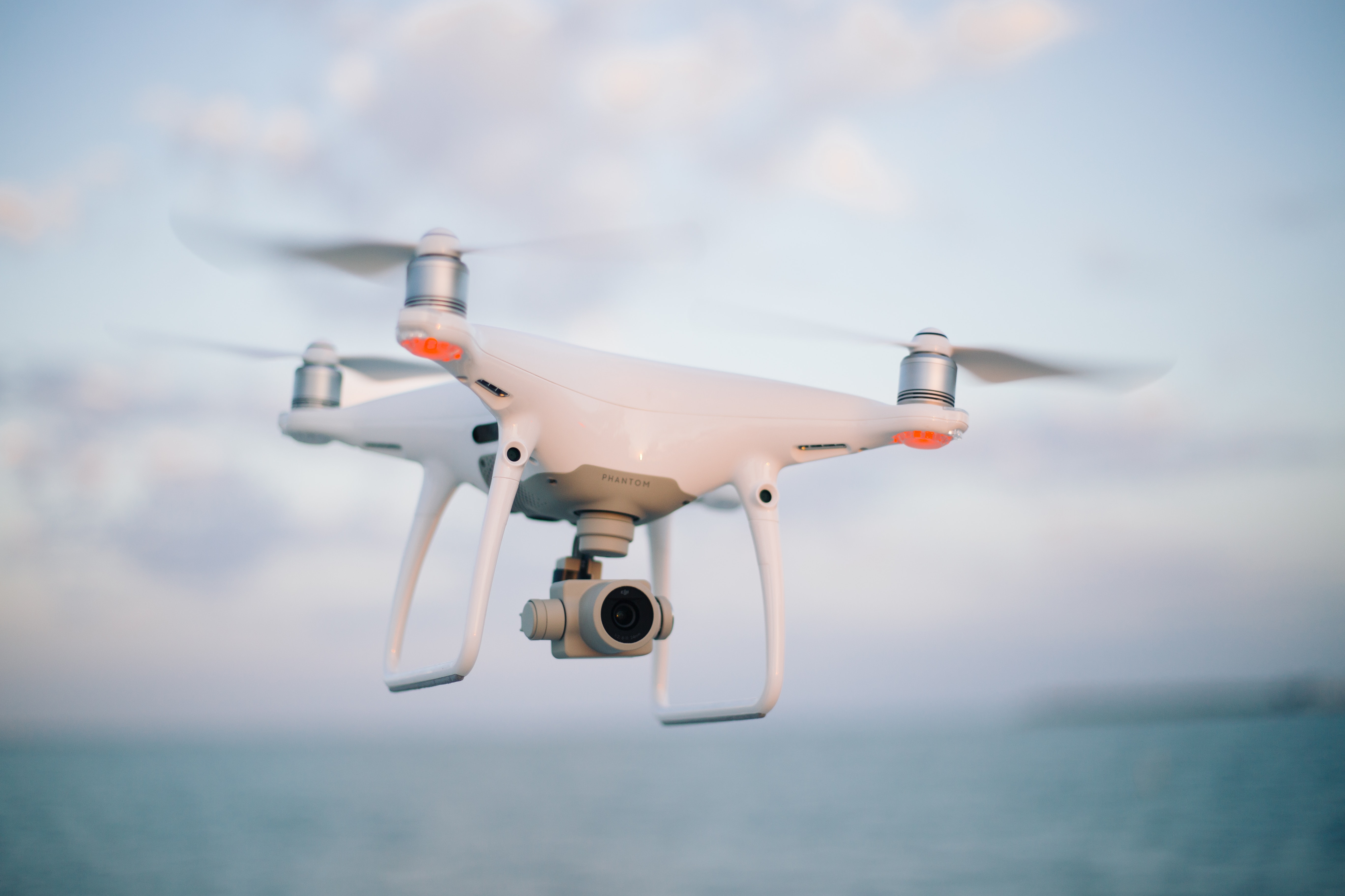
12. What Is Obstacle Avoidance?
Obstacle avoidance means that the drone attempts to detect something in its flight path and respond before hitting it.
The basic idea sounds simple:
See obstacle → calculate distance → decide what to do → change flight path.
The difficult part is every step after "see."
A camera might detect a tree.
But is the tree directly in the flight path?
How far away is it?
Is the branch moving?
Can the drone safely fly around it?
Is the apparent object actually a shadow?
What happens if another object is hidden behind it?
Different drones use different combinations of cameras and distance sensors to answer such questions.
More advanced systems can create representations of their surroundings and use path-planning algorithms to select a safer route.
However, obstacle avoidance should never be interpreted as a guarantee that a drone cannot crash.
Sensors have blind spots.
Low light can reduce camera performance.
Thin wires can be difficult to detect.
Glass can confuse sensors.
Rain, fog, dust and snow can interfere with perception.
Autonomy reduces risk; it does not eliminate physics.
13. Where Artificial Intelligence Enters the Picture
Artificial intelligence is increasingly important in drone technology, but the term can be misleading.
A drone does not necessarily need generative AI to be intelligent in a useful engineering sense.
Many autonomous tasks depend on computer vision, machine learning, classification and motion planning.
For example, a drone might use an onboard model to distinguish between:
- road
- building
- tree
- person
- vehicle
- open ground
It could then use that information for navigation or mission planning.
Machine learning can also help with inspection.
A drone flying along a power line might collect thousands of images. Software can search those images for patterns associated with damage.
In agriculture, aerial imagery can be analyzed to identify differences in crop health.
USDA research has explored UAV-based multispectral, hyperspectral and LiDAR sensing combined with machine learning for agricultural analysis, including drought-stress and soil-moisture mapping.
The key distinction is between collecting information and understanding information.
A camera collects pixels.
AI can help turn those pixels into useful categories or predictions.
14. Why Do Drones Have Gimbals?
A drone may be moving in one direction while the camera needs to remain pointed steadily at a subject.
That is where the gimbal comes in.
A gimbal is a mechanical stabilization system that allows the camera to rotate independently from some of the aircraft's movements.
Imagine carrying a tray of water while walking.
Your body moves up and down, but you instinctively keep the tray relatively level.
A camera gimbal performs a mechanical version of that stabilization.
Motors constantly make small corrections to counteract aircraft movement.
This allows a drone to produce smooth video even when the aircraft is accelerating, turning or encountering mild turbulence.
Some systems also use electronic image stabilization to further reduce vibration.
The combination can produce footage that looks surprisingly cinematic from a very small aircraft.
15. Why Are Drone Motors So Important?
Most consumer multirotors use electric motors.
The motor turns the propeller.
The propeller generates thrust.
But the motor must respond extremely quickly.
If the flight controller needs a tiny increase in thrust, the motor must accelerate rapidly.
If the drone needs to correct a roll, some motors may need to increase speed while others decrease speed.
This is why electronic speed controllers are important.
The flight controller sends commands to the motor-control electronics, which regulate how much electrical power reaches each motor.
The entire chain is extremely fast:
Sensor → flight controller → motor command → motor response → new aircraft motion → sensor measurement.
Then the loop begins again.
This feedback loop is fundamental to stable flight.
16. The Battery: The Drone's Greatest Constraint
A modern drone can contain remarkably sophisticated electronics, but none of them matter if the battery cannot keep the aircraft in the air.
Most small drones use rechargeable lithium-based battery technology because it provides a useful combination of energy density, power delivery and weight.
But batteries create a difficult engineering trade-off.
More battery capacity generally means more weight.
More weight requires more thrust.
More thrust requires more power.
More power consumes more battery.
That creates a cycle.
This is why simply installing a gigantic battery does not automatically give a drone unlimited flight time.
The aircraft must carry the battery.
And carrying the battery requires energy.
17. Why Weather Matters So Much
A drone may look perfectly capable in a product demonstration, but the atmosphere can be unforgiving.
Wind is particularly important.
A quadcopter can compensate for moderate wind by tilting into it.
But that requires additional thrust and therefore additional energy.
Strong wind can reduce endurance.
Rain introduces another problem.
Water can interfere with electronics, sensors and visibility, depending on the aircraft's design and weather resistance.
Cold temperatures can also affect battery performance.
Heat can create its own problems by increasing thermal stress.
Then there is turbulence.
A small aircraft has relatively little mass and can react strongly to gusts.
This is why professional drone operators consider weather forecasts, wind conditions, visibility and the aircraft's operating limits rather than treating a drone like a toy that can fly in any conditions.
18. How Does the Remote Controller Talk to the Drone?
A typical consumer drone maintains a wireless communication link with its controller.
The link can carry:
- control commands
- telemetry
- battery information
- positioning information
- video
- warnings
- system status
The controller sends instructions upward.
The drone sends information back.
This is another feedback loop.
The pilot might command the drone to move forward.
The aircraft responds.
The controller may simultaneously receive live video and telemetry.
The pilot can therefore operate a complex flying machine without physically touching it.
Communication links also introduce an important limitation.
Radio communication is not magical.
Range, interference, obstacles, antenna orientation and local regulations can affect performance.
A sophisticated drone still needs a reliable method of maintaining safe control.
19. What Is Remote ID?
As drones become more common, authorities need ways to identify aircraft operating in the airspace.
In the United States, the FAA's Remote ID framework requires drones that are required to be registered, or that are registered, to comply with Remote ID, subject to the applicable exceptions and mechanisms. Standard Remote ID drones broadcast identification and location information; compliant broadcast modules can provide another route, while FAA-recognized identification areas provide a specific option for certain aircraft without Remote ID.
The idea is somewhat like a digital license plate.
It does not mean that every person on the ground can necessarily identify the operator in the same way they might read a car license plate.
Rather, it creates a standardized way for compliant aircraft to broadcast specified identification and location information.
Remote identification is part of a much larger effort to integrate drones into existing airspace safely.
20. How Do Autonomous Drones Know Where to Go?
A basic autonomous mission can be built from waypoints.
A waypoint is essentially a location the drone is instructed to visit.
Imagine giving a delivery driver a list:
- Start here.
- Go to this intersection.
- Turn toward this building.
- Stop above this location.
- Return home.
The drone can receive a similar sequence of geographic instructions.
Its navigation system continuously estimates where it is.
The flight controller compares the current position with the desired position.
The guidance system calculates a direction.
The aircraft moves.
As it approaches the waypoint, the system adjusts its trajectory.
This can be surprisingly sophisticated when terrain, obstacles, wind and airspace constraints are included.
NASA's work on UAS Traffic Management has explored technologies such as dynamic geofencing, congestion management and terrain avoidance to support increasingly complex low-altitude drone operations.
21. What Is a Drone's "Return to Home" Function?
One of the most familiar autonomous features on consumer drones is Return to Home.
The basic concept is simple.
The drone remembers or receives a home position.
If the operator activates Return to Home—or if certain predefined conditions occur—the aircraft attempts to navigate back toward that location.
The drone may climb to a predetermined altitude first to reduce the chance of hitting obstacles.
But this function has an important limitation.
"Home" is not the same thing as "safe."
If the home point was recorded incorrectly, if the environment has changed, or if obstacles are not detected properly, an automated return can still create danger.
This is why pilots should understand the aircraft's settings rather than assuming automation eliminates responsibility.
22. What Are Drones Used For in 2026?
The applications have expanded far beyond photography.
NASA identifies uses including aerial photography, agriculture, communications, conservation, infrastructure inspection, fire support, law enforcement, search and rescue, weather monitoring and scientific research.
Photography and filmmaking
Drones can produce perspectives that once required helicopters.
They are useful for landscapes, events, real-estate photography, films and television.
Mapping
A drone can photograph the same area from many angles.
Software can combine those photographs into maps or three-dimensional models.
Agriculture
Farmers and researchers can use aerial imagery to observe crop conditions, plant stress, irrigation patterns and field variability.
Infrastructure
Drones can inspect:
- bridges
- roofs
- towers
- power lines
- pipelines
- roads
- construction sites
The advantage is not merely speed.
It can also reduce the need to place humans directly in hazardous positions.
Emergency response
After a disaster, roads may be blocked or unsafe.
A drone can rapidly survey an area and send imagery to responders.
NASA research has highlighted uses including damage mapping, reconnaissance, search and rescue, infrared detection and infrastructure inspection.
Weather research
Drones can also carry scientific instruments.
NOAA's National Severe Storms Laboratory has used uncrewed aircraft for atmospheric research and storm-damage surveys, with thousands of flights conducted since 2021.
23. How Does Drone Delivery Work?
Drone delivery is one of the most frequently discussed applications—and one of the most misunderstood.
A delivery drone must do much more than carry a package.
- receive a delivery mission;
- calculate or receive an approved route;
- navigate safely;
- avoid hazards;
- maintain communications;
- manage its battery;
- carry the payload securely;
- reach the destination;
- complete the delivery;
- return or proceed to another authorized location.
Regulation becomes especially important.
In the United States, Part 107 allows certain package transportation operations under specific conditions, while more complex operations involving compensation and beyond-visual-line-of-sight flight can require additional regulatory authorization. The FAA's Part 135 framework is used for certain commercial package-delivery operations.
In November 2026, the FAA announced an authorization for Skyways to conduct long-range drone operations beyond the operator's visual line of sight over the Gulf of America for infrastructure inspection and a simulated delivery mission.
That is significant because it demonstrates the direction of the industry: longer-range, increasingly autonomous operations are becoming technically and regulatorily possible, but they are still being integrated carefully rather than simply being allowed everywhere.
24. Why Can't Every Drone Simply Fly Anywhere?
The sky is already occupied.
Airliners, helicopters, military aircraft, emergency aircraft and general aviation all use airspace.
A drone does not become harmless simply because it is small.
A collision with a helicopter, for example, can be catastrophic.
That is why aviation authorities establish rules concerning altitude, locations, aircraft registration, pilot qualifications, visual line of sight, controlled airspace and other operational conditions.
In the United States, recreational flyers have specific requirements, including registration in applicable cases, the TRUST safety test, visual line of sight and compliance with airspace restrictions. Commercial and many other non-recreational operations generally fall under Part 107 or another applicable regulatory framework.
The European Union uses a different regulatory framework. EASA divides UAS operations into open, specific and certified categories, with different requirements depending on the risk and nature of the operation.
The details vary considerably between countries.
Therefore, a rule that is correct in one country may be completely wrong in another.
25. What Is Beyond Visual Line of Sight?
BVLOS means beyond visual line of sight.
Under ordinary visual-line-of-sight operations, the pilot or required observer can maintain the aircraft within direct visual sight as required by the applicable rules.
BVLOS changes the problem dramatically.
If the pilot cannot see the drone, the aircraft needs stronger systems for:
- navigation
- communications
- detect-and-avoid
- contingency management
- airspace coordination
- system reliability
The FAA proposed a broader regulatory framework for routine BVLOS operations in 2025, including technologies and services intended to support scalable low-altitude operations.
As of 2026, BVLOS operations are increasingly being authorized and tested, but that does not mean unrestricted BVLOS flying has become universally legal.
This distinction matters.
Technology may be capable of something long before regulation permits it routinely.
26. Can Drones Really Fly Completely by Themselves?
Sometimes, but "autonomous" is a spectrum.
A drone can be:
- directly controlled by a human;
- assisted by stabilization;
- controlled by a human while automatically avoiding some obstacles;
- programmed to follow waypoints;
- capable of automatically returning home;
- capable of tracking a subject;
- capable of planning portions of its route;
- designed to perform a mission with limited human intervention.
These are different levels of autonomy.
A drone following ten predefined GPS waypoints is not equivalent to a machine independently deciding what mission to perform in an unfamiliar city.
The latter requires much more sophisticated perception, planning, decision-making and safety validation.
Research is advancing rapidly, but fully general-purpose aerial autonomy remains a difficult engineering problem.
27. The Hidden Problem: Knowing What You Don't Know
One of the biggest challenges for autonomous drones is not simply seeing an object.
It is understanding uncertainty.
Imagine a drone flying toward something that looks like an open gap.
Is it really open?
Is there transparent glass?
Is there a thin wire?
Is the object farther away than the camera estimates?
Is the camera image blurred by motion?
Is a strange shape a tree branch or a person?
Humans use context, experience and multiple senses.
Machines must infer those things from sensors.
This is why autonomous drone research focuses not only on perception, but also on risk management.
NIST has specifically highlighted cybersecurity and AI risk management as important issues for increasingly connected and automated uncrewed systems, especially in safety-critical applications.
28. Cybersecurity: A Flying Computer Needs Protection
A drone is also a computer network with wings.
That creates cybersecurity risks.
Potential concerns include:
- unauthorized access
- communication interference
- compromised software
- manipulated navigation data
- stolen imagery
- malicious control
- attacks against supporting cloud systems
The more connected and autonomous the aircraft becomes, the more important cybersecurity becomes.
A drone used to inspect a roof may simply be carrying valuable photographs.
A drone used for infrastructure, emergency response or industrial operations can carry much more sensitive information.
NIST's work on uncrewed-system cybersecurity emphasizes that increasing connectivity and automation introduce new risks that need to be managed systematically.
29. Why Drones Are So Useful
The fundamental advantage of a drone is not simply that it can fly.
It is that it can put sensors and machines into places where humans do not need to go first.
NASA describes many UAS applications in terms of tasks that can be dull, dangerous, dirty or otherwise difficult for humans.
A drone can inspect a damaged roof before a worker climbs onto it.
It can survey a flooded region before emergency crews enter.
It can collect images from a wildfire perimeter.
It can examine crops across hundreds of hectares.
It can fly into environments where sending a helicopter would be expensive.
The technology therefore changes the economics of observation.
Instead of asking a person to physically reach every location, organizations can sometimes send a small flying robot first.
30. The Future of Drones Is Not Just Smaller Helicopters
The most interesting development is the transition from remote-controlled aircraft toward robotic aerial systems.
A future drone may not simply wait for a pilot to tell it every movement.
Instead, the human may define a mission:
"Inspect this bridge."
"Map this field."
"Search this area."
"Deliver this package."
"Monitor this coastline."
The drone then handles more of the low-level work.
That requires better sensors, better batteries, better navigation, stronger communications, more reliable AI and clearer rules.
It also requires something less glamorous but equally important:
trust.
People must know that the system will behave predictably when something goes wrong.
Practical Guide: Understanding a Drone From the Ground Up
1. Start with the propellers
Watch a quadcopter hover.
Remember that its basic lift comes from accelerating air downward.
2. Learn the three movements
Understand pitch, roll and yaw.
These three rotations explain much of a multirotor's movement.
3. Think of the motors as control surfaces
A drone controls itself primarily by changing motor speeds rather than moving traditional airplane control surfaces.
4. Learn the sensor loop
The drone senses its motion, estimates its state, calculates a correction and changes motor output.
Then it repeats.
5. Understand GPS correctly
GPS provides positioning information.
It is not the entire flight-control system.
6. Watch what happens in wind
A drone hovering in wind must tilt and increase thrust to compensate.
That consumes energy.
7. Look at the camera separately from navigation
The camera used for photography may not be the same camera used for navigation or obstacle detection.
8. Learn the battery trade-off
More energy means more weight.
More weight requires more energy.
This is one of the central engineering challenges of aerial robotics.
9. Check local regulations before flying
Never assume that a rule from another country applies where you live.
In the United States, for example, the FAA's rules cover registration, recreational operations, commercial operations, airspace and Remote ID.
10. Treat autonomous features as assistance, not magic
Return-to-home, obstacle avoidance and automated flight can be extremely useful.
They should not replace responsible operation, situational awareness or compliance with aviation rules.
Known vs. Uncertain
What is well established?
The basic physics of multirotor flight is well understood.
Propellers generate thrust. Motors control propeller speed. Differential motor speeds control attitude and movement. Sensors provide measurements, while feedback-control algorithms stabilize the aircraft.
Satellite navigation, inertial measurement, cameras, optical flow, barometric altitude sensing and other technologies are established components of modern drone systems.
Drones are also demonstrably useful for aerial photography, mapping, agriculture, inspection, emergency response and scientific research. NASA, NOAA, USDA and other organizations actively use or research UAS technology for these purposes.
What is improving rapidly?
Autonomous navigation, computer vision, AI-assisted perception, detect-and-avoid technology, long-range operations and UAS traffic management are all developing rapidly.
The underlying technologies are real.
The question is increasingly how reliably, safely and economically they can operate outside controlled environments.
What remains uncertain?
It is difficult to predict exactly when highly autonomous drones will become routine everywhere.
Battery energy density remains a major constraint.
Weather remains difficult.
Reliable detection of thin wires, transparent surfaces and unexpected objects remains challenging.
AI systems can make mistakes.
Cybersecurity threats will evolve alongside drone connectivity.
Regulations also vary by country and continue to change.
The result is a technology that is advancing quickly but should not be described as universally autonomous, universally safe or universally permitted.
FAQ: 20 Questions About How Drones Work
1. How does a drone stay in the air?
A drone stays airborne when the upward thrust produced by its propellers balances or exceeds its weight. The flight controller constantly adjusts motor speeds to maintain that balance.
2. How does a quadcopter move forward?
It tilts forward by changing the relative thrust of its motors. Once tilted, part of the total thrust points forward and accelerates the aircraft.
3. Why do drone propellers spin in different directions?
Opposing propellers help cancel the rotational torque that would otherwise make the aircraft spin uncontrollably.
4. Does a drone need GPS to fly?
No. Many drones can remain controllable without GPS, although satellite navigation can greatly improve positioning and autonomous navigation.
5. How does a drone know which way it is facing?
It can estimate orientation using gyroscopes, accelerometers, magnetometers, navigation systems and other sensors, depending on the aircraft.
6. How does a drone hover?
The flight controller continually adjusts motor speeds so that thrust balances gravity while correcting unwanted movement caused by wind and other disturbances.
7. What happens if the drone loses GPS?
The result depends on the aircraft and its software. Some systems can continue using inertial and visual sensing, while others may become less capable or enter a predefined safety mode.
8. Can drones see obstacles?
Many modern drones can detect some obstacles using cameras, optical sensors, LiDAR, infrared or other technologies. Detection capability varies substantially by model and environment.
9. Can a drone see in the dark?
Some drones can use thermal or low-light cameras, but ordinary visible-light cameras become much less effective in darkness.
10. How long can a drone fly?
Flight time depends on battery capacity, aircraft weight, payload, weather, speed and flight profile. Small consumer drones commonly operate for tens of minutes rather than hours.
11. Why don't drones simply use bigger batteries?
A larger battery also adds weight. The aircraft then needs more thrust, which consumes more energy, reducing some of the benefit of the additional battery capacity.
12. Can drones fly in rain?
Only if the specific aircraft is designed and rated for the relevant conditions. Water resistance varies considerably between drones, and rain can also reduce sensor and camera performance.
13. Can drones fly without a human pilot?
Some drones can perform autonomous or highly automated missions, but the level of autonomy varies. Legal requirements may also still require human supervision or responsibility.
14. What is a flight controller?
It is the onboard computer system that interprets sensor measurements and commands and uses them to control the aircraft's motors and other systems.
15. What is a drone gimbal?
A gimbal is a motorized mechanical stabilization system that allows a camera to remain relatively steady while the aircraft moves.
16. Can drones deliver packages?
Yes. Drone delivery is already operating in some regulated environments, but commercial delivery—especially beyond visual line of sight—requires compliance with applicable aviation rules and authorizations.
17. Can drones fly beyond the pilot's visual line of sight?
Yes, some operations are authorized to do so, but BVLOS operations are subject to specific regulatory requirements. They are not automatically legal simply because a drone has the technical ability to fly farther than the pilot can see.
18. Are drones controlled by AI?
Some drones use AI and machine learning for computer vision, object recognition, navigation or other tasks. Many flight-control functions, however, rely on conventional control algorithms rather than generative AI.
19. Can a drone be hacked?
Like other connected computing systems, drones can face cybersecurity risks. The risk depends on the aircraft, communications architecture, software, network connections and operational environment.
20. Will drones become completely autonomous?
Greater autonomy is highly likely, but completely independent operation in every environment is much harder. Reliable perception, safety, communications, airspace integration, cybersecurity, energy and regulation all have to advance together.
Conclusion
The next time you see a drone hovering above a field, do not think of it simply as a camera with four propellers.
Think of the machine as a miniature flying laboratory.
Its motors are constantly adjusting.
Its sensors are measuring.
Its computer is estimating.
Its navigation system is calculating.
Its communications link is carrying information.
Its camera is collecting the world as data.
And its software is continuously deciding how to turn all of that information into controlled movement.
The most remarkable part is not that a drone can fly.
Humanity has understood controlled flight for more than a century.
The remarkable part is how much intelligence can now be packed into an aircraft small enough to fit in a backpack.
In 2026, drones are moving steadily from remotely controlled machines toward increasingly autonomous robotic systems. They are inspecting infrastructure, studying storms, monitoring crops, mapping landscapes, helping emergency responders and beginning to support longer-range commercial operations.
But the future will not be determined by motors and cameras alone.
It will depend on batteries, reliable sensors, trustworthy AI, cybersecurity, airspace management and regulation.
The drone of tomorrow therefore will not simply be a better flying camera.
It will be a more capable robot.
And the central question will gradually change from "Can a machine fly itself?" to a much more important question:
"Can we make a machine that knows when it should—and should not—fly itself?"
Sources
- NASA — What Is an Uncrewed Aircraft System? NASA's educational background material explains UAS components, autonomous operation and major civilian applications. NASA UAS background and applications
- NASA JPL — Unmanned Aircraft Systems Covers autonomous aerial research, GPS-denied navigation, onboard computation and experimental UAS platforms. NASA JPL Unmanned Aircraft Systems
- FAA — Remote Identification of Drones Official information on Remote ID requirements, broadcast modules and FAA-recognized identification areas. FAA Remote ID
- FAA — Small Unmanned Aircraft Systems Regulations, Part 107 Current FAA overview of operational requirements for small UAS. FAA Part 107 regulations
- FAA — Getting Started With Drones Official guidance for recreational and certificated drone pilots. FAA Getting Started
- FAA — Drone Registration Registration requirements and current registration information. FAA Drone Registration
- FAA — Package Delivery by Drone Information on commercial UAS delivery and Part 135 operations. FAA Package Delivery by Drone
- FAA — Long-Range BVLOS Authorization, November 2026 Information about the November 2026 authorization for long-range operations over the Gulf of America. FAA November 2026 BVLOS authorization
- NASA — UAS Traffic Management Explains research into geofencing, congestion management, terrain avoidance and low-altitude drone traffic management. NASA UAS Traffic Management
- EASA — Easy Access Rules for Unmanned Aircraft Systems, June 2026 Official European framework covering open, specific and certified UAS categories. EASA UAS rules, June 2026
- EASA — Drone Operator Registration and Pilot Competency Information on European drone categories, pilot competency and certificates. EASA Drone Operator and Pilot Requirements
- NOAA National Severe Storms Laboratory — Uncrewed Aircraft Describes NOAA's use of UAS for severe-weather research and storm-damage surveys. NOAA Uncrewed Aircraft Research
- USDA Agricultural Research Service — UAV Remote Sensing Research Examples of UAV-based hyperspectral, LiDAR and AI-assisted agricultural research. USDA UAV remote-sensing research
- NIST — Cybersecurity and AI Risk Management for Uncrewed Systems Research addressing cybersecurity and AI risks in increasingly connected autonomous systems. NIST UAS cybersecurity and AI risk management
- Wikimedia Commons — Quadcopter Drone in Flight Real photograph by Project Kei, captured 2 August 2020, licensed CC BY-SA 4.0. Wikimedia Commons photo — Project Kei

The conversation
Post a Comment