Imagine looking down at a rainforest from hundreds of kilometers above Earth. Thick clouds cover the canopy, and rain is falling steadily. An ordinary camera sees a blanket of white. But a remarkable satellite can collect information about what is happening below, even when clouds hide the surface.
This is the promise of NISAR, a powerful Earth-observing satellite jointly developed by NASA and the Indian Space Research Organisation (ISRO). Launched on July 30, 2025, NISAR entered its science operations phase in early 2026. By July 2026, both NASA and ISRO had announced the availability of the mission's first data products, marking a transition from commissioning to routine scientific use.
Unlike traditional imaging satellites, NISAR does not depend on daylight or clear skies. It sends radar signals toward Earth and measures the echoes that return. Those echoes reveal information about ground movement, forests, ice, water, and cities, often with remarkable precision.
The satellite is designed to help scientists investigate earthquakes, shifting glaciers, changing forests, and other dynamic processes. Its greatest contribution may be something less dramatic but more scientifically powerful: the ability to create repeated, high-resolution maps of Earth's changing surface.
To understand why this matters, we need to explore how radar can reveal Earth's hidden movements, what makes NISAR unusual, and how scientists are learning to interpret its data.
1. Why Earth Needs a Different Kind of Camera
For decades, satellites have provided extraordinary pictures of our planet. They have photographed deserts, oceans, forests, and cities in vivid detail. Optical satellites collect sunlight reflected from Earth's surface. Different surfaces reflect different wavelengths of light, producing familiar images that resemble photographs.
This approach has revolutionized environmental science, but it has a major weakness. Clouds can obstruct the view. In tropical regions, persistent cloud cover makes regular optical monitoring challenging. During floods, storms, or volcanic eruptions, the sky is often cloudy at exactly the moment when information is most urgently needed. Nighttime adds another limitation for instruments that rely on reflected sunlight.
Radar offers an alternative. Instead of waiting for sunlight, a radar instrument generates its own electromagnetic signals. It transmits pulses toward Earth and records the signals reflected back. The result is not a conventional photograph. It is a radar image built from the strength, timing, phase, and polarization of returning signals.
Radar can operate during the day or night. At the frequencies used by NISAR, it can also observe through clouds and, in some cases, through parts of vegetation. That does not mean radar can see through everything. Dense vegetation, complicated terrain, and unusual surface conditions can still create challenges. Nevertheless, radar allows scientists to observe regions that optical satellites cannot consistently monitor. This is especially valuable when studying environmental changes over months and years.
A photograph can show how a place looks. Repeated radar measurements can reveal how that place is changing.
2. What Makes NISAR Different?
NISAR stands for NASA-ISRO Synthetic Aperture Radar. The mission combines engineering expertise from two national space agencies. NASA developed the L-band radar instrument, while ISRO developed the S-band instrument and the spacecraft bus, and launched the observatory from India.
Its most distinctive feature is the combination of two radar wavelengths aboard one observatory. The L-band instrument uses microwaves with a wavelength of approximately 24 centimeters, while the S-band instrument uses a shorter wavelength of about 10 centimeters. Because these signals interact differently with vegetation, soil, and other surface features, their combined observations provide complementary information.
The spacecraft also carries an enormous deployable radar reflector measuring approximately 12 meters across. This is roughly the width of a large room, yet it had to be folded into a compact configuration for launch. After reaching orbit, the reflector opened into its operational shape. The antenna's size is important because collecting faint radar echoes from hundreds of kilometers away requires a large collecting area.
NISAR also uses a technique known as SweepSAR, which helps combine broad surface coverage with useful spatial detail. According to ISRO, the system can observe a swath approximately 240 kilometers wide while following a 12-day repeat orbit. The combination is unusual. A satellite that produces detailed measurements over only a narrow strip may require substantial time to revisit the same location. A satellite that covers enormous areas at low resolution may overlook important changes. NISAR is designed to reduce that compromise, offering repeated observations across extensive parts of the planet. That creates opportunities to understand not simply where something happened, but how it developed.
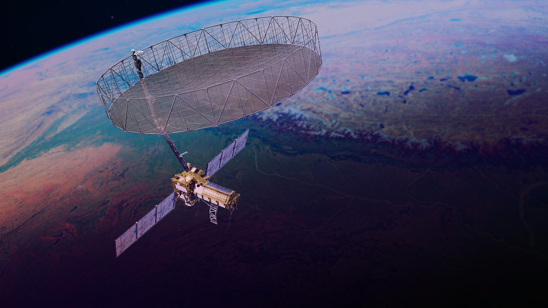
Photo 1: NASA/JPL-Caltech artist's concept of NISAR in orbit, showing its large deployable radar reflector antenna.
3. How Radar Turns Invisible Echoes Into Images
The basic idea behind radar is surprisingly familiar. Imagine shouting inside a large cave. Your voice travels outward, encounters the cave walls, and produces echoes. By measuring how long the echo takes to return, you can estimate how far away the reflecting surface is. Radar works on a related principle, but instead of sound waves, it uses electromagnetic waves.
NISAR sends microwave pulses toward Earth's surface. Those signals interact with objects such as trees, soil, water, buildings, and ice. A portion of the transmitted energy returns to the satellite. Scientists call this returned signal backscatter. The strength of backscatter depends on multiple factors, including surface roughness, moisture, geometry, and the properties of the material.
Smooth water often reflects radar energy away from the satellite, producing relatively dark areas in radar images. Buildings and other structures may reflect energy strongly, particularly when their orientation creates a corner-like geometry. Forests produce complex echoes because branches, trunks, leaves, and the ground all interact with the radar signal. However, these interactions are not enough to explain NISAR's extraordinary imaging capabilities.
The satellite relies on synthetic aperture radar, usually abbreviated SAR. A conventional radar system's ability to distinguish nearby features is influenced partly by its antenna size. Building an enormous rigid antenna in space would be difficult and expensive. Synthetic aperture radar solves part of this problem through movement and computation. As the satellite travels along its orbit, it transmits and receives many radar pulses from slightly different positions. A processor combines the information from these observations to simulate the performance of a much larger antenna. This creates detailed images without requiring a physically enormous rigid structure.
There is another critical measurement hidden inside those radar echoes: the phase of the returning wave. Phase describes the position within a wave's repeating cycle. Comparing phase information from different observations can reveal extraordinarily small changes in distance between the satellite and the ground. That capability becomes essential when scientists study earthquakes, volcanoes, and slow ground movement.
4. Detecting Ground Movement Before It Becomes Obvious
Earth's surface may appear solid and unchanging, but it is constantly moving. Tectonic plates shift. Mountains rise and erode. Underground fluids move through rock. Sediments compact. Many of these processes occur too slowly for people to notice. A road may sink gradually over several years. A hillside may move only a few millimeters in a month. Scientists need precise measurements to distinguish these movements from ordinary environmental variation.
One important technique is called interferometric synthetic aperture radar, or InSAR. It compares radar observations of the same location acquired at different times. When the viewing geometry and surface conditions allow, differences in radar phase can be used to estimate surface displacement. For example, imagine that a hillside moves slightly toward the satellite between two observations. The returning radar signal may travel a shorter distance during the second measurement. Even when that difference is too small to see in an ordinary image, phase comparisons may reveal it.
The calculations require careful correction for orbital geometry, atmospheric effects, and other sources of error. Scientists often combine multiple observations and ground-based measurements to improve confidence. NISAR is particularly useful because repeated acquisitions can support the creation of long-term displacement records. These records may reveal gradual deformation near faults, volcanic areas, and unstable slopes. However, detecting movement is not the same as predicting a disaster. Scientists cannot reliably forecast the precise date, time, location, and magnitude of an earthquake. Satellite radar cannot eliminate that limitation. Its value lies in helping researchers understand geological processes, map deformation, and assess conditions that may increase risk. Over time, these measurements can improve models of how Earth's crust responds to stress.
5. A New Perspective on Earthquakes
When a major earthquake strikes, the damage visible at the surface tells only part of the story. Buildings collapse, roads crack, and landslides may block valleys. Beneath the surface, faults can move across extensive regions. Understanding that movement helps scientists determine what happened during the earthquake and how the surrounding landscape responded.
Traditional ground instruments such as seismometers and GPS receivers provide extremely important measurements. But these instruments are installed at specific locations. A satellite can examine movement across a much larger landscape, including remote areas where ground instruments are sparse. Radar interferometry produces maps of surface displacement that sometimes contain striking bands of color called fringes. Each fringe represents a particular change in radar phase. Researchers interpret these patterns to reconstruct the distribution of ground movement. This information can help identify areas of uplift, subsidence, or horizontal movement, although a single observation rarely tells the complete story. Multiple viewing geometries and additional measurements improve the picture.
Satellite observations can also help identify deformation associated with secondary hazards. For example, a landslide may continue moving after an earthquake. Repeated radar measurements can help researchers investigate that continuing instability. The practical importance is significant. Infrastructure planners may use deformation maps alongside geological surveys and engineering inspections. Emergency management teams can benefit from satellite observations of inaccessible terrain. But satellite data must be interpreted carefully. Radar may struggle where the ground has changed dramatically, vegetation has moved, or the surface no longer reflects signals consistently. NISAR is therefore an additional scientific instrument, not a replacement for local monitoring, fieldwork, and ground-based instruments. Its strength comes from providing a broad, repeated perspective that complements observations on the ground.
6. Watching Forests Beyond Their Green Appearance
Forests play a central role in Earth's climate system. They store carbon, influence rainfall, protect soil, provide wildlife habitats, and support communities. But monitoring forests is much more complicated than measuring how much of the landscape appears green. Two forests can look similar in an optical satellite image while containing very different quantities of wood and carbon. A young forest recovering from disturbance may have extensive leafy cover but much less aboveground biomass than a mature forest. That distinction matters for understanding carbon storage.
Trees absorb carbon dioxide through photosynthesis and incorporate carbon into their tissues. Estimating forest biomass helps researchers investigate how much carbon is stored in living vegetation and how that storage changes over time. NISAR offers an additional way to study this problem. Its L-band radar can penetrate parts of forest canopies and interact with woody vegetation and the ground. The resulting echoes contain information about vegetation structure and other surface properties. In combination with ecological models, field measurements, and observations from other satellites, radar data can contribute to biomass estimates.
However, the relationship is not simple. Radar backscatter depends on moisture, tree geometry, vegetation density, and surface conditions. Very dense forests can also create measurement challenges, including saturation effects that make it difficult to distinguish further increases in biomass. Scientists therefore calibrate and validate radar-based estimates rather than treating a single image as a direct measurement of carbon.
Repeated observations are particularly valuable. Imagine a forest recovering after a wildfire. An optical satellite might show vegetation gradually returning. Radar observations could provide complementary evidence about changes in vegetation structure as recovery progresses. Now imagine a forest where selective logging has removed large trees without completely clearing the canopy. The changes may be difficult to recognize using only conventional imagery. Radar time series may help reveal disturbances that deserve further investigation. The scientific opportunity is not simply to count trees. It is to understand how forests gain, lose, and redistribute biomass over time. That could improve carbon accounting, conservation planning, and research into how ecosystems respond to climate change.
7. The Remarkable Radar Image of a Maine Island
One of NISAR's early observations demonstrated how different a radar view can be from an ordinary photograph. On August 21, 2025, the satellite's L-band instrument captured Mount Desert Island, off the coast of Maine. The image was released publicly in September 2025. Instead of showing familiar natural colors, it displayed the island through a combination of radar measurements. Forest areas appeared green. Water appeared dark. Hard or regularly shaped surfaces, including buildings and other infrastructure, appeared in magenta tones. The town of Bar Harbor stood out on the northeastern part of the island.
The image was not intended to reproduce what human eyes would see from an airplane. Its colors communicated properties of the radar signals returning from different surfaces.

Photo 2: NISAR radar image of Mount Desert Island, acquired August 21, 2025. Forests appear green, water appears dark, and built-up or hard surfaces appear magenta. Credit: NASA/JPL-Caltech.
Why does this image matter? Because it illustrates a fundamental difference between optical and radar observations. A colorful radar image is not necessarily showing the natural color of the landscape. Scientists assign colors to different measurements to make patterns easier to recognize. That is especially helpful when comparing urban surfaces, vegetation, and water.
In March 2026, NASA's Jet Propulsion Laboratory released additional examples showing how NISAR had captured the Pacific Northwest through clouds. Those images demonstrated how radar could examine forests, waterways, cities, and mountains despite persistent cloud cover. Scientists emphasized that comparisons across multiple dates would be more informative than isolated images. A single image establishes a starting point. A series of images can become a record of change. That distinction explains why repeated observations are so important to NISAR's scientific mission.
8. Following Water Through Floods and Wetlands
Water is one of Earth's most dynamic resources. Rivers expand during heavy rainfall. Wetlands fill and drain. Agricultural fields become saturated. Monitoring these processes is challenging because floods frequently occur under thick clouds. Optical imagery may therefore be unavailable at critical moments. Radar offers a different perspective. Open, relatively smooth water often produces weak backscatter because much of the radar energy reflects away from the satellite. This can create dark regions that help scientists identify flooded areas.
However, identifying water is not always straightforward. Rough water, vegetation standing in floodwater, urban structures, and other surfaces can complicate interpretation. For example, trees growing in shallow water may produce unusual radar reflections between their trunks and the water surface. Under suitable conditions, those reflections can help researchers identify flooded vegetation. NISAR's observations could therefore contribute to maps showing how wetland boundaries and flood extents change.
Consider a river basin where seasonal flooding supports agriculture and wildlife. The floodwaters may expand across an enormous area, then retreat as the season changes. Repeated radar observations can help document that cycle. Researchers can compare the extent and timing of floods across different years to investigate environmental change. Such information may also support water-resource planning. In agricultural regions, understanding soil moisture and surface flooding can help researchers investigate growing conditions and water availability.
But satellite measurements should not be mistaken for complete assessments of water availability. Water depth, groundwater storage, water quality, and local infrastructure conditions require additional information. Radar is one part of a larger observation system. Its special contribution is the ability to repeatedly map surface characteristics even during cloudy weather. This is particularly valuable in tropical and monsoon regions, where optical coverage can be inconsistent.
9. Agriculture: Understanding Crops Without Relying on Sunshine
Modern agriculture depends on understanding changing conditions across large areas. Farmers need information about crop development, soil moisture, drought, flooding, and the timing of harvests. Traditional field observations remain essential, but they can be difficult to collect consistently across large regions. Satellites help close that information gap. Optical measurements can reveal changes in leaf color and vegetation reflectance. Radar provides complementary information about crop structure, surface roughness, and moisture.
Different crops interact with radar signals in different ways. Young plants, mature vegetation, exposed soil, and recently harvested fields can produce distinct patterns. Those patterns may also change with irrigation, rainfall, and agricultural practices. By combining radar time series with weather records, optical observations, and field measurements, researchers can investigate crop development and environmental conditions. NISAR's dual-frequency system could be especially useful for studying how different vegetation structures respond to radar signals at different wavelengths.
One potential application involves distinguishing changes caused by crop growth from changes caused by soil moisture. Another involves examining agricultural landscapes during cloudy growing seasons. Yet radar is not an automatic crop-health detector. A bright or dark radar signal does not independently reveal whether a plant is healthy. Similar radar patterns can arise from different combinations of moisture, vegetation, and soil conditions. Reliable interpretation requires models that account for local agriculture and environmental factors. This illustrates an important principle in Earth observation: a measurement becomes useful when researchers understand what it represents. For agriculture, NISAR's greatest value may emerge through integration with other information rather than through any single image.
10. Tracking the Slow Transformation of Ice
Glaciers and ice sheets are among the most important indicators of environmental change. They respond to variations in temperature, snowfall, ocean conditions, and internal ice dynamics. Some glaciers move slowly. Others flow much faster, particularly near their outlets. Understanding their movement is essential for investigating the transfer of ice toward the ocean and its contribution to sea level.
Satellite radar provides a powerful way to study ice motion. By comparing recognizable radar patterns between observations, scientists can estimate how far a glacier has moved. In appropriate conditions, interferometric techniques can also provide displacement information. NISAR was designed to contribute to measurements of glaciers, ice sheets, and sea ice, including areas that are difficult to reach on the ground. Polar regions are particularly challenging because darkness can persist for extended periods during winter. Radar does not depend on sunlight, making it valuable for monitoring during those seasons.
The scientific questions are substantial. How quickly are particular glaciers accelerating? Are changes in surface movement linked to seasonal melting? How do glaciers respond to changes in snowfall, temperature, and the conditions at their bases? What happens when ice becomes unstable near the ocean? Repeated radar observations can help researchers examine these processes. However, glacier movement is not equivalent to ice loss. A glacier may move faster without immediately providing enough information to calculate how much mass it is losing. Researchers must combine velocity measurements with ice thickness, elevation changes, snowfall, melt, and ocean data. Similarly, monitoring sea ice requires distinguishing ice motion, distribution, thickness, and seasonal change. No single instrument measures every property equally well. NISAR's contribution is to strengthen the range and frequency of available radar observations, giving scientists a more complete view of ice in motion.
11. What a Satellite Can Reveal About Cities
Urban areas are constantly changing. New buildings appear. Roads expand. Land is excavated. Underground water extraction can cause gradual sinking. Some changes happen quickly. Others develop so slowly that they remain unnoticed until damage becomes visible. Radar interferometry can help investigate gradual movement across urban landscapes.
Imagine a city built partly on soft sediments. Over time, groundwater extraction or the natural compaction of underlying materials may cause parts of the city to subside. That movement can affect roads, pipelines, buildings, and drainage systems. Repeated radar observations can support maps showing patterns of surface displacement. Researchers can then compare those patterns with geological information, groundwater records, and engineering data. Such comparisons may help identify areas where further investigation is worthwhile.
Radar is particularly effective over some stable artificial surfaces that provide consistent reflections. Buildings and other fixed structures can make useful radar targets under suitable imaging conditions. But urban environments also create complications. Tall buildings can block radar signals or produce geometric distortions. Construction activity may change the reflecting surface between observations. Scientists must account for these limitations before interpreting displacement maps. It is also important not to confuse movement detection with structural safety certification. NISAR cannot determine whether a particular building is safe simply by observing its surrounding ground. Engineering inspections, local measurements, and other forms of analysis remain necessary. The larger value lies in identifying landscape-scale patterns that would be difficult to discover through isolated ground surveys. As cities grow, this kind of environmental monitoring could become increasingly useful for infrastructure planning.
12. Why Open Satellite Data Matters
One of the most important aspects of NISAR is not a piece of hardware. It is the decision to make scientific observations publicly accessible. NASA's NISAR mission page confirms that its data are archived through the Alaska Satellite Facility. NASA announced the release of provisional L-band products on July 20, 2026, and ISRO reported the availability of S-band products around the same period. Open scientific data can change who is able to participate in research. A university studying landslides may gain access to observations covering difficult terrain. An environmental organization may investigate changes in a wetland. A research group in a developing country may use satellite measurements without having to build or launch its own spacecraft. Students can learn how radar measurements relate to physical properties of the landscape. And independent researchers can test new methods against a common body of observations.
This does not mean every dataset is immediately easy to use. Raw and processed radar products can be technically complex. They may require specialized software, substantial storage, calibration information, and an understanding of radar processing. Users also need to distinguish provisional products from fully validated scientific measurements. That distinction is important because data quality improves as researchers compare satellite observations with ground measurements and refine processing methods. Nevertheless, making the observations accessible encourages collaboration. Scientific understanding advances when researchers can reproduce analyses, compare results, and discover errors. Open data also creates opportunities for developing useful tools. For example, software developers may design systems that simplify radar interpretation, create visualizations, or combine satellite data with local information. The satellite supplies observations. Researchers and developers turn those observations into knowledge.
13. Can Artificial Intelligence Help Interpret Radar Data?
NISAR produces a rich and complex stream of scientific measurements. Turning those measurements into reliable information requires sophisticated processing. Artificial intelligence may play an increasingly useful role in that process. Machine-learning systems can be trained to recognize patterns in large collections of satellite observations. For instance, researchers may develop models that help identify flooded land, classify vegetation, or detect unusual ground movement. AI systems may also help prioritize locations for closer investigation. Imagine examining hundreds of radar images covering an extensive mountain range. A model could search for patterns consistent with changing ground movement and identify areas that merit expert review. This could reduce the amount of repetitive screening required.
But AI cannot automatically solve the underlying scientific challenges. A model trained on one region may perform poorly in another. Radar characteristics differ with terrain, vegetation, moisture, season, and viewing geometry. An algorithm may mistake agricultural changes for flooding or interpret atmospheric disturbances as ground movement. Models need independent evaluation using reliable reference information. There is another issue: explainability. For scientific applications, it is not always enough for an algorithm to produce an answer. Researchers need to understand why a particular classification or prediction was made and whether the result is trustworthy. The strongest approach combines satellite observations, established radar-processing methods, AI-assisted analysis, and human expertise. In this role, artificial intelligence becomes a tool for extracting information from complicated measurements, not a replacement for scientific judgment.
14. The Limitations Scientists Must Overcome
NISAR is powerful, but its capabilities have boundaries. Radar images can contain distortions caused by steep terrain, overlapping reflections, or surfaces that change between observations. Atmospheric conditions can influence the phase of radar signals, potentially introducing errors into displacement measurements. Vegetation movement, changing moisture, and surface disturbance can make observations from different dates difficult to compare. Scientists refer to an important aspect of this problem as loss of coherence. When radar echoes become insufficiently consistent between acquisitions, precise interferometric measurements become difficult. This is particularly challenging in rapidly changing landscapes.
There are also limits to the frequency of observation. Although NISAR follows a 12-day repeat-orbit cycle and has broad coverage capabilities, this does not mean it observes every location continuously. Events can occur between satellite passes. Some changes may therefore be observed only after they happen. Other events may need much faster monitoring than a periodic satellite can provide. This is why NISAR should be understood as part of a larger Earth-observation network. Optical satellites, weather instruments, ground sensors, aircraft, ocean measurements, and field research all contribute different kinds of information. Their combined observations offer a more complete understanding than any individual system could provide alone. The challenge for scientists is not merely to gather more data. It is to determine what those data mean, how uncertain the measurements are, and which conclusions they can support.
15. What Happens Next?
As NISAR continues its science operations, the long-term value of its observations should become clearer. Scientists will be able to compare radar measurements collected across seasons and, eventually, multiple years. That historical depth matters. A single image may reveal a flooded landscape. A longer sequence can help establish whether flooding is becoming more frequent, whether a wetland is shrinking, or whether a forest is recovering. A single measurement may show ground deformation. A time series can help distinguish gradual motion from sudden changes. A single observation may reveal a forest disturbance. Repeated measurements can help researchers examine recovery.
Over the coming years, some of the most valuable discoveries may emerge from relationships between different kinds of change. Researchers could investigate how rainfall influences landslide movement, how forest disturbances affect local hydrology, or how ice movement responds to seasonal conditions. These investigations will require careful validation and collaboration across scientific disciplines. The satellite's measurements are not answers by themselves. They are evidence from which answers may gradually emerge. For interested readers, NISAR's official mission website and publicly available image galleries provide accessible starting points for exploring its observations. The most revealing developments may not be spectacular individual images. They may be changes discovered only after scientists compare thousands of observations.
16. Conclusion: A Planet That Never Stands Still
From the ground, Earth often appears stable. Mountains seem permanent. Cities appear fixed. Forests can look unchanged from one year to the next. Yet the planet is continuously transforming. Rivers reshape landscapes. Ice moves toward the sea. Forests grow and recover. Tectonic forces slowly deform the crust. Many of these processes remain difficult to understand because they occur across enormous distances and over long periods.
NISAR offers scientists a different perspective. By transmitting radar signals from orbit, measuring the returning echoes, and revisiting extensive regions again and again, it creates a systematic record of change. Its dual-frequency instruments, large antenna, and systematic observations make it an important addition to Earth science. The scientific promise is not that NISAR can predict every earthquake, detect every flood, or explain every environmental change. It cannot. Its contribution is more fundamental: providing repeated, detailed observations that allow researchers to test ideas, refine models, and recognize patterns that were previously hidden.
In an era when understanding environmental conditions is increasingly important, that knowledge has practical value. Better observations can support stronger scientific models, more informed planning, and deeper understanding of a changing planet. NISAR reminds us that some of Earth's most important changes happen almost invisibly. And sometimes, to see them clearly, we need to look beyond visible light.
Sources and Further Reading
- NASA — NISAR Mission Overview: Mission objectives, instruments, science operations, and data availability.
- NASA — NISAR Mission Phases: Launch, commissioning, and science operations.
- NASA/JPL — NISAR's First Radar Images: September 2025 image release.
- NASA/JPL — NISAR Captures the Pacific Northwest Through Clouds: March 2026 observations and scientific applications.
- ISRO — NISAR S-Band Data Products Release: July 2026 radar data availability and technical specifications.
- ISRO Bhoonidhi — NISAR Data Access: Information about accessing and visualizing satellite products.
Category: Science & Technology | Space Science | Earth Observation
The conversation
Post a Comment