El Niño 2026–2027: The Weather Pattern That Could Change Everything
Imagine waking up to a world in which two neighbouring countries are experiencing completely different weather emergencies. In one, farmers are watching their crops disappear because the rainy season has failed. In another, rivers are overflowing, roads are underwater and communities are preparing for floods. Thousands of kilometres away, fishermen are reporting changes in their catches, electricity companies are worrying about water levels in reservoirs, and food markets are reacting to uncertainty about the next harvest.
These events might appear unrelated. Yet they can share an important influence: a warming region of the Pacific Ocean.
That influence is called El Niño, and the 2026–2027 event is attracting extraordinary attention from climate scientists, governments, agricultural organisations and businesses.
El Niño is not a hurricane, a single storm or a sudden worldwide temperature increase. It is a natural climate phenomenon involving the interaction between ocean temperatures and atmospheric circulation. Its effects can spread across continents, changing the probability of particular weather conditions for months at a time.
What makes the current event particularly important is its projected intensity.
The World Meteorological Organization (WMO), in its October 26, 2026 seasonal outlook, warned that the developing event could be unprecedented in strength. Its November 2026–January 2027 outlook projects a seasonal average Niño 3.4 sea-surface temperature anomaly of approximately 3.8°C above average. The WMO expects the event to peak towards the end of 2026, although its consequences could continue well into 2027.
The International Research Institute for Climate and Society (IRI) also reported exceptionally strong oceanic and atmospheric signals in October. Meanwhile, NOAA's October assessment placed the probability of a strong-to-very-strong El Niño continuing through January–March 2027 above 83%.
For readers following online trends, the subject is also attracting growing search interest. The current editorial keyword estimate places searches for El Niño at approximately 12,100 per month, around twelve times the previous year's level. These figures are estimates from keyword research, not a precise count of every search.
But what does this phenomenon actually mean for ordinary people?
Could it increase food prices? Could it worsen drought in already water-stressed countries? Could it bring damaging rainfall to other regions? And what should households, farmers and governments do before the strongest effects arrive?
Understanding the answers requires looking beneath the surface of the Pacific Ocean.
1. What Exactly Is El Niño?
El Niño is the warm phase of a larger natural climate pattern known as the El Niño–Southern Oscillation, usually abbreviated to ENSO.
ENSO describes a recurring interaction between the tropical Pacific Ocean and the atmosphere above it. It has three main phases:
- El Niño: Unusually warm sea-surface temperatures develop in the central and eastern equatorial Pacific.
- La Niña: Those same regions become unusually cool.
- ENSO-neutral: Neither the warm nor the cool phase is established.
These conditions influence atmospheric circulation, which affects where clouds form, where rain falls and how heat moves around the planet.
The phenomenon generally returns every two to seven years, although the intervals are not perfectly regular. Individual events also differ in duration and strength. Many last approximately nine to twelve months, while some persist longer.
The name El Niño means "the little boy" in Spanish. Historical accounts associate the term with Peruvian fishermen who noticed unusual changes in ocean temperatures and fishing conditions around the Christmas period.
The name may sound harmless, but the consequences can be significant.
How do scientists officially identify El Niño?
Scientists do not declare an El Niño simply because the Pacific Ocean experiences a few unusually warm days.
They monitor a specific area called Niño 3.4, located in the central-eastern equatorial Pacific. Sea-surface temperatures are compared with a long-term average.
NOAA's operational criteria include a sustained temperature anomaly of at least +0.5°C across five consecutive overlapping three-month periods, together with evidence that the atmosphere is responding to the warmer ocean.
This atmospheric response is essential.
A warm patch of ocean without the corresponding changes in winds and tropical rainfall does not necessarily represent a fully established El Niño event.
The ocean and atmosphere must work together.
That is why scientists monitor wind patterns, atmospheric pressure, cloud formation, rainfall and temperatures beneath the ocean surface rather than relying on a single thermometer.
2. How Does El Niño Form?
To understand El Niño, imagine the tropical Pacific Ocean as an enormous swimming pool with a constant wind blowing across its surface.
Under normal conditions, easterly trade winds blow from the eastern Pacific towards the west. They push warm surface water towards Indonesia, Papua New Guinea and northern Australia.
This creates an important temperature difference across the ocean.
The western Pacific becomes particularly warm, while cooler water rises from deeper layers near the coast of South America.
This process is called upwelling.
The colder water brings nutrients towards the surface, supporting marine ecosystems and important fisheries. Meanwhile, the warm western Pacific encourages evaporation, cloud formation and heavy tropical rainfall.
In simple terms, the atmosphere normally receives much of its tropical Pacific heat and moisture in the western part of the ocean.
El Niño changes this arrangement.
Step 1: Trade winds weaken
The easterly trade winds become weaker than usual. In some periods, temporary westerly wind bursts help push warm water eastwards.
The warm water that normally accumulates in the western Pacific begins moving towards the central and eastern Pacific.
Step 2: The ocean's temperature distribution changes
As warmer water spreads eastwards, the temperature difference between the western and eastern Pacific becomes smaller.
The thermocline, which separates warmer surface water from colder deeper water, changes its shape and becomes deeper in the eastern Pacific.
This reduces the ability of cold water to reach the surface near South America.
The result is a further increase in surface temperatures.
Step 3: Rainfall moves eastwards
Warm ocean water transfers heat and moisture into the atmosphere.
As the central and eastern Pacific become warmer, the areas where tropical clouds and thunderstorms develop can shift eastwards.
Indonesia and neighbouring areas may experience suppressed rainfall, while parts of the central and eastern Pacific receive more rain.
Step 4: A feedback loop strengthens the event
The atmospheric changes can weaken the trade winds further.
Weaker winds allow additional warm water to move eastwards. That warming changes the atmosphere again, creating conditions that can reinforce the original disturbance.
Scientists describe this as a coupled ocean–atmosphere feedback.
NASA's October 2026 satellite analysis shows how sea-surface temperature, ocean colour and sea-level measurements are being used to monitor the developing event. Its observations also reveal how the 2026 Pacific pattern resembles some features of the powerful 1997 event.
Source: NASA's 2026 satellite observations.
3. Why Is El Niño 2026–2027 So Concerning?
Not every El Niño creates the same level of disruption.
Some are relatively weak. Others become strong enough to influence weather patterns across several continents.
The 2026–2027 event is attracting attention because several independent monitoring organisations are reporting unusually strong signals.
The latest scientific measurements
The October 19 IRI update reported that the traditional Niño 3.4 index had reached a seasonal average of +2.46°C during July–September 2026. Its September monthly value was +2.84°C, while the weekly value centred on October 14 reached +3.3°C.
The institute also reported strongly negative Southern Oscillation Index readings, indicating a pronounced weakening of the Walker circulation.
These are important observations because they show that the atmosphere is responding to the ocean warming.
What do the forecasts predict?
| Organisation | Latest relevant finding |
|---|---|
| NOAA | More than 83% chance of strong-to-very-strong conditions through January–March 2027 |
| WMO | Approximately +3.8°C seasonal mean Niño 3.4 anomaly forecast for November–January |
| IRI | All 27 participating models forecast a very strong event for October–December through December–February |
| NASA | Satellite observations show similarities between the 2026 and 1997 ocean patterns |
The IRI's October model ensemble also projected an average Niño 3.4 anomaly of approximately +3.5°C for October–December and November–January.
These figures should not be treated as identical measurements. They involve different forecast systems, observation periods, climatological baselines and statistical methods. They nevertheless point towards the same broad conclusion: an exceptionally strong event is developing.
NOAA also estimated an 83% chance that the event would exceed its historic three-month relative Oceanic Niño Index threshold during October–December.
It is important to understand the distinction between a very strong event and a guaranteed disaster.
A powerful El Niño increases the likelihood of certain climate conditions. It does not tell scientists exactly which town will experience flooding or precisely when a particular drought will begin.
Could it become stronger than the 1997–1998 event?
NASA's October 23, 2026 comparison of satellite altimetry data revealed similarities between the current event and the 1997–1998 El Niño.
The comparison is particularly interesting because the 1997–1998 event was among the strongest in modern observational records.
NASA project scientist Josh Willis noted that the 2026 event was on track to become even bigger, based on the sea-level patterns being observed.
However, NASA also stressed that similar ocean patterns do not guarantee identical weather consequences.
The atmosphere is complex, and the final impact depends on how the event evolves.
Source: NASA, El Niño Then and Now.
4. How Could El Niño Change Rainfall Around the World?
The most important effect of El Niño is not that it makes every place hotter or drier.
It changes the distribution of rainfall and temperature.
Some regions become more likely to experience drought. Others face increased rainfall and flooding.
The following patterns are based on established climate relationships and the latest seasonal outlooks. They are not guarantees for individual locations.
East Africa: More rainfall and flood risks
Parts of East Africa are traditionally associated with increased rainfall during El Niño, particularly during the October–December short-rains season.
Countries and areas that may be exposed include:
- Kenya.
- Somalia.
- Tanzania.
- Parts of Ethiopia.
- Uganda and neighbouring areas, depending on the season and local circulation.
Heavy rainfall can benefit farmers and improve water availability.
However, excessive rainfall can create serious problems.
Flooding can destroy crops, damage roads, contaminate drinking-water sources and displace communities. Landslides may threaten settlements located on steep or unstable terrain.
The WMO's October 26 outlook identifies wetter-than-normal conditions as more likely in parts of East Africa during the October–December rainy season.
Southern Africa: Drought and agricultural pressure
Southern Africa faces a different risk.
El Niño has historically been associated with reduced rainfall during the main agricultural season across several countries in this region.
Areas at risk include:
- Zimbabwe.
- Zambia.
- Botswana.
- Namibia.
- Parts of South Africa.
- Mozambique and neighbouring countries.
A failed rainy season can have consequences far beyond individual farms.
Livestock need pasture and drinking water. Farmers need enough soil moisture for planting. Hydroelectric facilities depend on sufficient water entering reservoirs.
When rainfall remains below normal for several months, these systems can come under simultaneous pressure.
The WMO's October outlook warns of increased drought risks in Southern Africa from November 2026.
Southeast Asia: Heat, drought and smoke
Indonesia, the Philippines and parts of mainland Southeast Asia can experience warmer and drier conditions during El Niño.
The consequences can include:
- Reduced rainfall.
- Lower river and reservoir levels.
- Greater pressure on irrigation.
- Increased wildfire risk.
- Agricultural losses.
- Smoke and haze affecting populated areas.
Indonesia is particularly exposed because its agricultural and ecological systems depend heavily on seasonal rainfall.
When peatlands and vegetation become unusually dry, fires can spread more easily. Smoke can travel across national borders, affecting air quality in neighbouring countries.
The WMO's latest seasonal outlook highlights warmer conditions and rainfall deficits in Southeast Asia.
Australia: A greater risk of dry conditions
El Niño is often associated with hotter and drier conditions across parts of eastern and northern Australia.
This can increase pressure on farmers, water managers and rural communities.
Dry vegetation can also contribute to dangerous bushfire conditions.
However, Australia has a highly variable climate. A particular El Niño does not mean that every Australian state will experience drought.
South America: Floods in some areas, drought in others
The western coast of South America is particularly important because El Niño develops in the Pacific waters bordering the continent.
Coastal Ecuador and northern Peru can experience unusually heavy rainfall during strong events.
This creates risks of:
- Flash floods.
- River flooding.
- Landslides.
- Damage to roads and bridges.
- Agricultural losses.
- Disruption to fishing communities.
Farther south, rainfall patterns can be different.
Parts of southern Brazil, Uruguay and Argentina are often associated with wetter-than-average conditions during El Niño.
Meanwhile, northern South America and the Amazon can face increased drought risk.
Central America and the Caribbean: Water stress
Central America is another region that can experience reduced rainfall during El Niño.
The Dry Corridor, which extends across parts of Guatemala, Honduras, El Salvador and Nicaragua, is particularly vulnerable.
Agricultural communities in this region often depend on seasonal rainfall for maize and other essential crops.
A delayed rainy season can cause farmers to lose an entire planting opportunity.
Water shortages may also affect households, electricity production and local businesses.
The WMO's October outlook identifies increased drought risk in parts of Central America and the southern Caribbean.
North America: A changing winter pattern
In the United States, El Niño can influence the position and strength of the Pacific jet stream.
The southern United States often has increased chances of wetter winter conditions, while northern areas can experience relatively warmer conditions.
Parts of California and the southern states may receive more winter rainfall.
However, more rainfall is not automatically good news.
If rain arrives too quickly, soils may become saturated, rivers can rise and flood risks can increase.
The strength and location of individual storm systems remain uncertain.
What about Morocco and North Africa?
This is a particularly important question for readers in Morocco, Algeria, Tunisia and neighbouring countries.
El Niño can influence atmospheric circulation across the North Atlantic and Mediterranean regions. However, its rainfall signal in North Africa is much less straightforward than the traditional patterns observed in parts of the tropical Pacific and southern Africa.
Morocco's rainfall is influenced by several interacting factors, including:
- The North Atlantic Oscillation.
- Mediterranean atmospheric circulation.
- Atlantic sea-surface temperatures.
- Regional storm tracks.
- Other large-scale climate patterns.
A 2026 review published in Communications Earth & Environment explains that North African rainfall has strong spatial and seasonal variability and that ENSO relationships over the Mediterranean depend on the time of year.
Therefore, it would be irresponsible to claim that El Niño alone guarantees a dry or wet winter in Morocco.
For Moroccan households and farmers, local forecasts from the Directorate General of Meteorology remain much more useful than global El Niño headlines.
North Africa precipitation research, 2026.
5. Could El Niño Make 2027 Even Hotter?
One of the most important consequences of a strong El Niño is its influence on global temperatures.
The tropical Pacific stores enormous amounts of heat. When El Niño develops, changes in ocean circulation and atmospheric conditions redistribute some of that heat into the atmosphere.
This can temporarily increase global average temperatures.
The effects are often most noticeable in the year following the development of an event.
That timing matters for the 2026–2027 cycle.
If the current event reaches its expected peak near the end of 2026, its influence on global temperatures could remain important during 2027.
But there is another factor: human-caused climate change.
The planet is already warming because greenhouse gases trap additional heat in the climate system.
El Niño is a natural variation operating on top of that long-term warming trend.
The two influences can combine.
The previous major event provides a useful example. The WMO confirmed that 2024 was the warmest year in its 175-year observational record, with a global mean temperature approximately 1.55°C above the 1850–1900 average.
The WMO attributed the record heat to human-induced climate change combined with El Niño and other natural influences.
This does not mean that El Niño alone caused the record.
It means that natural climate variability can temporarily push global temperatures higher in a world already experiencing long-term warming.
Scientists do not have evidence that climate change is increasing the frequency or intensity of El Niño events. However, a warmer background climate can amplify some of the impacts associated with extreme heat and heavy rainfall.
WMO State of the Global Climate 2024.
6. Why Agriculture Could Be One of the Biggest Victims
Agriculture is closely connected to the weather.
A farmer cannot simply move a planting season because the rain has arrived late. Seeds, soil moisture, temperatures and water availability must work together.
This makes agriculture particularly vulnerable to El Niño.
Consider a farmer who normally plants maize at the beginning of the rainy season.
If the first rains fail, the farmer may delay planting. But if the next rainfall period is also weak, the crop may not receive enough water to develop properly.
The consequences can include reduced yields or complete crop failure.
Crops most exposed to weather disruption
Different regions depend on different agricultural products, but several major crops can be affected:
Rice: Rice production depends heavily on reliable water supplies, particularly in rain-fed systems.
Maize: Drought during important growth stages can reduce yields dramatically.
Wheat: The effects vary by production region, seasonal rainfall and temperatures.
Sugarcane: Water stress can reduce growth and affect production in important exporting countries.
Coffee and cocoa: Temperature and rainfall changes can affect flowering, fruit development and disease pressure.
Livestock: Drought can reduce pasture, increase the cost of animal feed and limit drinking water.
The problem is not limited to failed harvests
A drought can create a chain reaction.
First, farmers produce less food. Then, they may need to purchase more expensive animal feed or water.
If their income falls, they may borrow money to finance the next planting season.
If the following season also fails, debt increases and household savings disappear.
This can eventually lead to livestock sales, migration and greater food insecurity.
The Food and Agriculture Organization (FAO) warns that agricultural drought risks are particularly important in the Sahel, Southern Africa, South and Southeast Asia, and Central America's Dry Corridor.
Its June 2026 analysis identified agricultural areas where the historical probability of drought during strong ENSO events can exceed 50%.
The organisation and the World Food Programme also launched a joint anticipatory-action appeal seeking $202 million to protect 8.8 million people across 22 high-risk countries.
FAO's agricultural risk assessment.

7. Could El Niño Increase Food Prices?
This is where a distant ocean phenomenon can become a household economic problem.
Imagine that a major rice-producing country experiences reduced rainfall.
Harvests become smaller. Exporters have less rice available. Governments may introduce restrictions to protect domestic supplies.
International buyers then compete for a smaller quantity of available rice.
The result can be higher prices in importing countries.
This is not a theoretical possibility. The 2023–2024 El Niño provides a useful example.
The World Bank reported that rice prices increased by approximately 4% during the first quarter of 2024 and were around 28% higher than a year earlier.
The Bank identified supply concerns in major exporting countries associated with El Niño, alongside India's export restrictions, as important factors.
It is worth noting that prices subsequently retreated as market conditions changed.
This example demonstrates why El Niño should be taken seriously without assuming that every food product will become more expensive.
Which food products could be affected?
Depending on the countries and agricultural seasons involved, potential pressure points include:
- Rice.
- Maize.
- Sugar.
- Coffee.
- Cocoa.
- Vegetable oils.
- Animal feed.
- Some livestock products.
However, food prices depend on much more than weather.
Other important factors include:
- Existing global food stocks.
- Export restrictions and trade policies.
- Currency exchange rates.
- Transport and fuel costs.
- Fertiliser availability.
- Conflicts and political instability.
- The ability of farmers to adapt.
A country may experience a poor harvest without seeing a major increase in supermarket prices if it has sufficient reserves and alternative suppliers.
Another country may experience relatively modest agricultural losses but face severe price increases because it depends heavily on imports.
For consumers, the important issue is not simply whether El Niño becomes stronger. It is whether the event affects the crops and supply chains on which their country depends.
World Bank, Commodity Markets Outlook, April 2024.
8. What Happens to Oceans, Fisheries and Wildlife?
The effects of El Niño extend beyond rainfall and agriculture.
The Pacific Ocean contains some of the world's most important marine ecosystems.
Normally, cold upwelled water near the western coast of South America carries nutrients towards the surface.
These nutrients support phytoplankton, which form the foundation of many marine food chains.
Small fish feed on plankton. Larger fish feed on smaller fish. Seabirds and marine mammals depend on those fish populations.
El Niño can disrupt this system.
When warmer surface water reduces the normal upwelling process, fewer nutrients may reach the surface.
This can reduce the productivity of certain marine ecosystems.
Fish may migrate towards cooler waters or move to different depths.
Commercial fishing communities can consequently experience reduced catches or changes in the species available.
The effects can be particularly important for fisheries associated with Peru and Ecuador.
Coral reefs and marine heatwaves
El Niño can also contribute to marine heatwaves.
When ocean temperatures remain unusually high, corals can become stressed and expel the microscopic algae that provide much of their energy.
This process is known as coral bleaching.
Bleached corals are not necessarily dead, but prolonged heat stress can cause severe damage.
Other marine organisms may also struggle when temperatures rise beyond their normal range.
These impacts matter because healthy marine ecosystems support tourism, fishing, coastal protection and local employment.
9. El Niño Can Disrupt Electricity, Transport and Global Trade
One of the most surprising lessons from the previous El Niño was that a climate phenomenon in the Pacific could interfere with international shipping.
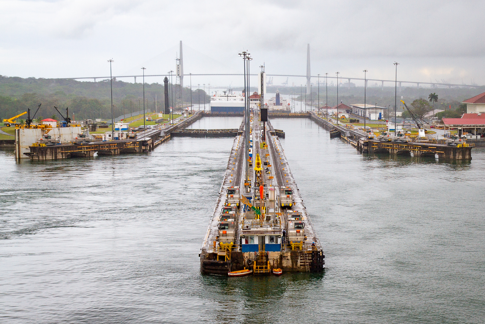
The Panama Canal depends on freshwater from surrounding lakes and rivers.
Ships passing through its locks require enormous quantities of water. That water ultimately depends on rainfall in the canal watershed.
During the 2023–2024 El Niño, Panama experienced serious rainfall shortages.
Water levels in Lake Gatún fell, forcing authorities to restrict the number and size of ships passing through the canal.
The result was not simply a local water problem.
Shipping delays affected international trade routes, transportation costs and supply chains.
The World Weather Attribution analysis published in May 2024 found that El Niño contributed to the low rainfall, while also identifying rising water demand and other local pressures.
This is an important distinction: El Niño contributed to the crisis, but it was not the only factor.
Hydroelectric power is another vulnerability
In countries that depend heavily on hydropower, prolonged drought can reduce electricity production.
The WMO's assessment of Africa's 2024 climate reported critically low water levels in Lake Kariba, contributing to electricity shortages in Zambia and Zimbabwe.
This demonstrates how one rainfall problem can affect several sectors simultaneously:
- Farmers lose production.
- Reservoirs receive less water.
- Electricity generation declines.
- Businesses face power interruptions.
- Households experience additional costs.
The effects of El Niño are therefore not limited to the weather forecast. They can influence the functioning of entire economies.
10. What Did the 2023–2024 El Niño Teach Us?
The previous event offers some of the clearest evidence of why the 2026–2027 situation deserves attention.
The 2023–2024 El Niño was one of the five strongest on record, according to the WMO.
Its effects were not identical everywhere.
Some regions experienced serious drought, while others faced devastating rainfall.
Southern Africa experienced severe drought
Several countries experienced major agricultural losses.
According to the WMO's State of the Climate in Africa 2024 report, aggregate cereal yields in Southern Africa were approximately 16% below the five-year average.
The estimated declines were particularly severe in:
- Zambia: approximately 43%.
- Zimbabwe: approximately 50%.
These were enormous losses for communities that depend on agriculture for food and income.
The drought also affected water resources and hydropower.
East Africa experienced severe flooding
The same broad El Niño period was associated with exceptionally heavy rainfall in parts of East Africa.
Flooding affected communities in Kenya and Tanzania, damaging infrastructure, agricultural land and homes.
The positive Indian Ocean Dipole also contributed to the regional climate conditions.
This is an important lesson: El Niño does not act alone. Other climate systems can reinforce or modify its influence.
The Panama Canal experienced shipping restrictions
The severe drought of 2023 reduced rainfall in the Panama Canal watershed.
Restrictions on ship movements continued into 2024 as water levels remained low.
The incident demonstrated how climate risks can travel through global supply chains.
The world experienced record temperatures
The WMO confirmed that 2024 was the warmest year in its observational record.
The combination of human-caused warming and the 2023–2024 El Niño contributed to the exceptional temperatures.
Food markets reacted to uncertainty
Rice prices rose substantially in early 2024 amid concerns about production in exporting countries and trade restrictions.
However, other agricultural commodities did not all follow the same direction.
The wider lesson is that El Niño can create market pressure, but the actual result depends on the product, region, harvest and trade environment.
The 2023–2024 event demonstrated something particularly important: climate risks become more damaging when they interact with existing economic and social vulnerabilities.
A wealthy country with strong infrastructure, insurance and water reserves may absorb a difficult season relatively well.
A rural community with limited savings, rain-dependent agriculture and few alternative income sources may struggle to recover.
WMO State of the Climate in Africa 2024.
11. El Niño vs La Niña: What Is the Difference?
El Niño and La Niña are opposite phases of the same climate system.
Both influence global weather, but their typical effects often point in different directions.
| Feature | El Niño | La Niña |
|---|---|---|
| Pacific temperatures | Warmer than average | Cooler than average |
| Trade winds | Weaker than normal | Stronger than normal |
| Eastern Pacific upwelling | Often reduced | Often enhanced |
| Rainfall over Indonesia | Often reduced | Often increased |
| Australia | Increased drought risk in some areas | Often wetter in eastern regions |
| Southern United States | Often wetter winters | Often drier winters |
| Atlantic hurricane activity | Usually suppressed | Often enhanced |
| Global temperature influence | Warming tendency | Cooling tendency |
These are typical statistical relationships, not guaranteed outcomes.
A strong La Niña does not mean that every location will experience heavy rainfall. Likewise, El Niño does not guarantee drought everywhere.
The two phases are part of a natural cycle that continually changes the distribution of heat and moisture across the planet.
Between them, neutral conditions can occur.
This transition period is important because climate systems do not switch instantly from one extreme to another.
12. What Are Scientists Watching During 2026–2027?
Scientists are not simply waiting to see whether the Pacific Ocean becomes warmer.
They are monitoring several interconnected indicators.
1. Niño 3.4 sea-surface temperatures
This is one of the main measurements used to classify ENSO conditions.
Scientists want to know whether the warming continues, reaches its peak and eventually begins to weaken.
2. Trade winds
Trade winds help determine where warm surface water accumulates.
Their strength and direction can reveal whether the ocean–atmosphere feedback remains active.
3. Subsurface ocean temperatures
A large reservoir of warm water beneath the surface can help sustain the event.
Scientists use ocean measurements to determine how much heat remains available below the surface.
4. Southern Oscillation Index
The Southern Oscillation Index measures atmospheric pressure differences between the western and eastern tropical Pacific.
Strongly negative values are generally associated with El Niño conditions.
5. Indian Ocean Dipole
The Indian Ocean Dipole can influence rainfall across East Africa, Australia and parts of Asia.
Its interaction with ENSO can change regional rainfall outcomes.
6. Global seasonal rainfall forecasts
The WMO, NOAA and national meteorological services continuously update their forecasts.
Scientists are particularly interested in whether expected rainfall patterns are appearing in observations.
The distinction between a seasonal outlook and a daily weather forecast is essential.
A seasonal forecast may indicate an increased probability of drought over a broad region. It cannot reliably tell a farmer the exact date on which rain will arrive.
7. How quickly the event weakens
A strong El Niño does not necessarily disappear when it reaches its maximum intensity.
Its effects can continue after the Pacific temperatures begin returning towards normal.
The latest IRI October outlook favours El Niño conditions through boreal spring 2027, with probabilities declining later in the year.
NOAA's next scheduled diagnostic discussion, as listed in its October assessment, is November 12, 2026.
13. Does Climate Change Make El Niño More Dangerous?
This question requires a careful distinction.
El Niño existed long before industrialisation. It is a natural feature of Earth's climate system.
Climate change did not create the phenomenon.
Scientists also do not currently have evidence that human-caused warming is increasing the frequency or intensity of El Niño events.
However, climate change can make some of the associated consequences more damaging.
Consider two situations.
In the first, an El Niño-related heatwave occurs in a world with a lower background temperature.
In the second, a similar weather pattern occurs after decades of global warming have raised average temperatures.
The same additional heat can push the second situation into more dangerous territory.
The same principle applies to heavy rainfall.
A warmer atmosphere can hold more moisture, increasing the potential for intense precipitation when suitable weather conditions develop.
FAO explains that El Niño now operates against a background of higher global temperatures, with consequences for agricultural drought, heat exposure, wildfires and flooding.
The combination of natural climate variability and long-term human-caused warming is therefore a central concern for 2026–2027.
14. How Can Ordinary People Prepare?
El Niño is a global phenomenon, but preparation is usually local.
A family in a flood-prone area needs different preparations from a farming household in a drought-prone region.
The best response is not panic buying or making predictions based on social media headlines.
It is understanding the risks that apply to the place where you live.
For households
Follow official weather information.
Check national meteorological services and local emergency announcements.
Do not rely exclusively on global climate headlines.
Prepare for possible water interruptions.
In areas vulnerable to drought, understand local water restrictions and maintain reasonable emergency supplies where appropriate.
Know your flood risk.
If you live near a river, drainage channel or flood-prone road, understand evacuation routes and keep important documents protected.
Prepare for heat.
Keep drinking water available, reduce unnecessary exposure during extreme heat and check on older people and vulnerable neighbours.
Protect essential equipment.
Power interruptions can affect communication, refrigeration and medical equipment. Know what alternatives are available in your area.
For farmers
Farmers can benefit from preparing before the planting season begins.
Useful actions include:
- Following seasonal forecasts from agricultural authorities.
- Choosing crops suited to expected rainfall conditions.
- Considering drought-tolerant seed varieties.
- Improving soil moisture retention.
- Maintaining irrigation systems.
- Protecting livestock feed supplies.
- Planning alternative water sources.
- Monitoring pests and crop diseases.
- Avoiding unnecessary planting decisions based on a single forecast.
In flood-prone regions, farmers may also need drainage plans, crop protection measures and ways to safeguard stored seeds and equipment.
For businesses
Businesses should consider whether their operations depend on agricultural supplies, water availability, transport or electricity.
A food company may need alternative suppliers.
A manufacturer may need a water conservation plan.
A logistics company may need alternative shipping routes.
A retailer may need to monitor the availability and cost of essential products.
The earlier these risks are identified, the more options businesses have.
For governments
Public authorities have a particularly important responsibility.
They should strengthen early-warning systems, prepare emergency services, maintain water infrastructure and support farmers before crop losses occur.
Investments in drainage, reservoirs, irrigation efficiency and resilient electricity systems can reduce the damage caused by extreme weather.
The FAO's anticipatory-action approach illustrates the value of acting before a climate shock becomes a humanitarian emergency.
15. What Should People in Morocco Pay Attention To?
For Morocco, the most useful approach is to distinguish between global climate information and local forecasts.
The country already faces substantial water-management challenges, and rainfall variability has important consequences for agriculture, reservoirs and rural livelihoods.
However, it would be misleading to claim that the 2026–2027 El Niño will automatically cause another Moroccan drought.
The relationship between ENSO and North African rainfall is complex and season-dependent.
Moroccan rainfall is also influenced by Atlantic circulation, Mediterranean weather systems and the North Atlantic Oscillation.
Residents should therefore follow:
- The Directorate General of Meteorology's official forecasts.
- Ministry of Agriculture advisories.
- Local reservoir and water-management information.
- Agricultural seasonal outlooks.
- Official heat, flood and drought warnings.
Farmers should pay particular attention to planting decisions and water availability rather than assuming that a global El Niño forecast predicts rainfall on their farms.
For urban households, sensible water conservation and attention to local water restrictions remain useful regardless of the ENSO phase.
16. The Biggest Risk May Be the Chain Reaction
El Niño is often described as a weather phenomenon.
That description is correct, but incomplete.
Its most important consequences may emerge when several systems experience stress at the same time.
Imagine a drought affecting an agricultural region.
The harvest declines. Livestock feed becomes more expensive. Farmers earn less money. Local food supplies tighten. Transport costs rise because alternative supplies must be brought in.
At the same time, low reservoir levels reduce electricity production.
Businesses face higher operating costs. Food prices increase. Families spend more of their income on essentials.
A climate event has now become an economic and social problem.
This chain reaction is why international organisations are paying so much attention to early warnings.
The aim is not to prevent El Niño, which is a natural phenomenon beyond human control.
The aim is to reduce the damage it can cause.
Conclusion: A Powerful Climate Signal, Not a Worldwide Disaster Forecast
El Niño 2026–2027 is one of the most important climate developments to watch as the world approaches 2027.
The latest forecasts indicate an exceptionally strong event, with the potential to influence rainfall, temperature, agriculture, food markets, fisheries, water supplies and global infrastructure.
The 2023–2024 event demonstrated how quickly these effects can spread from farms and reservoirs into international trade and household budgets.
But there is an important difference between understanding risk and predicting disaster.
El Niño does not make every country hotter, does not guarantee drought in every agricultural region and does not automatically produce a worldwide food crisis.
Its effects depend on local conditions and the interaction of several climate systems.
The most valuable response is preparation based on reliable regional information.
The Pacific Ocean may be thousands of kilometres away from most of the world's population, but its changing temperatures remind us how closely connected Earth's climate systems really are.
The world cannot stop El Niño. It can, however, become much better prepared for what comes next.
Key Takeaways
- El Niño 2026–2027 is already established and strengthening.
- WMO's October outlook projects an exceptionally strong event, with a Niño 3.4 seasonal anomaly of approximately +3.8°C for November–January.
- The strongest effects are expected to include changes in rainfall, drought risks, flooding and above-average temperatures.
- Southern Africa, Southeast Asia, parts of South Asia and Central America face important agricultural risks.
- Parts of East Africa and South America may experience increased rainfall and flooding.
- Food prices could face pressure if important agricultural regions experience poor harvests, but increases are not guaranteed.
- The 2023–2024 event showed how drought and flooding can disrupt agriculture, electricity and international shipping.
- Climate change raises the background temperature and can amplify some El Niño-related impacts, although El Niño itself is a natural phenomenon.
- Morocco's rainfall response is uncertain and should be assessed using local meteorological forecasts.
- Early warnings, water management and agricultural preparation are the most effective ways to reduce damage.
Frequently Asked Questions (FAQ)
1. What is El Niño 2026–2027?
El Niño 2026–2027 is a particularly strong phase of the El Niño–Southern Oscillation. It involves unusually warm sea-surface temperatures in the central and eastern equatorial Pacific and associated changes in atmospheric circulation. International forecasts indicate that it will remain strong into early 2027.
2. Is El Niño 2026–2027 expected to be the strongest ever?
It has the potential to rank among the strongest events in modern records. The WMO and IRI have reported exceptionally high temperature anomalies and strong model agreement. However, its final ranking will depend on the measurements used and how the event evolves.
3. Will El Niño cause a global food crisis?
Not necessarily. It can reduce agricultural production in vulnerable regions and increase pressure on food markets. However, food prices also depend on global stocks, trade policies, alternative suppliers, currencies and transport costs. A worldwide food crisis is not an automatic consequence.
4. Which countries are most vulnerable to El Niño?
Risks vary by season, but important areas include parts of Southern Africa, the Sahel, Indonesia, Australia, South and Southeast Asia, Central America's Dry Corridor and the Caribbean. Parts of East Africa may face increased flooding risk.
5. Will Morocco be affected by El Niño?
El Niño may influence North African atmospheric circulation, but its direct rainfall signal in Morocco is not sufficiently reliable to make a definite prediction. Local rainfall depends on several interacting systems, including Atlantic and Mediterranean circulation.
6. Does El Niño cause climate change?
No. El Niño is a natural climate phenomenon. Human-caused climate change is a separate long-term process driven primarily by greenhouse gas emissions. However, global warming can amplify some impacts associated with El Niño, particularly extreme heat and heavy rainfall.
7. How long will El Niño 2026–2027 last?
Current forecasts favour continued El Niño conditions into spring 2027, with gradual weakening later in the year. Its exact duration and transition towards neutral or La Niña conditions remain uncertain.
8. What is the difference between El Niño and La Niña?
El Niño involves warmer-than-average sea-surface temperatures in the central and eastern tropical Pacific. La Niña involves cooler-than-average temperatures in those areas. Both influence global rainfall and temperature patterns, often in opposite directions.
9. Can El Niño cause extreme heat?
Yes. El Niño redistributes heat from the tropical Pacific into the atmosphere and usually contributes to higher global average temperatures. It can increase the likelihood of extreme heat in certain regions, particularly when combined with long-term global warming.
10. How can ordinary people prepare?
People should monitor official local weather forecasts, understand their exposure to drought or flooding, conserve water where necessary and prepare for heat or possible service disruptions. Farmers should pay attention to seasonal agricultural guidance and planting conditions.
Sources and Further Reading
- World Meteorological Organization — October 2026 Global Seasonal Climate Outlook.
- NOAA Climate Prediction Center — ENSO Diagnostic Discussion, October 8, 2026.
- Columbia University IRI — October 2026 ENSO Forecast.
- NASA — Satellites Observe Historic 2026 El Niño.
- NASA — El Niño Then and Now, October 2026.
- FAO — El Niño and Agricultural Risks, June 2026.
- WMO — State of the Global Climate 2024.
- WMO — State of the Climate in Africa 2024.
- World Bank — Commodity Markets Outlook, April 2024.
- World Weather Attribution — Panama Canal Drought Analysis, May 2024.
- Communications Earth & Environment — Atmospheric Drivers and Precipitation Variability in North Africa, July 2026.
Editorial note: Forecasts and probabilities in this article reflect information available on November 6, 2026. Seasonal forecasts are updated regularly and should not be interpreted as predictions of individual storms or local weather events.
The conversation
Post a Comment