A river with no banks
On a winter morning in western Europe, the air may feel unexpectedly mild for its latitude. Across the Atlantic, a storm can gather energy over water that still holds summer's heat. Farther south, fishing communities watch the arrival of cooler, nutrient-rich water that helps determine which species can thrive. These places do not share a single forecast, yet they are connected by an ocean that continually moves heat between the tropics and the poles. One of the most recognizable pieces of that system is the Gulf Stream, a broad, swift current flowing along the western edge of the North Atlantic.
It is tempting to call the Gulf Stream the current that decides tomorrow's weather. That is too simple. Winds, pressure patterns, land, sea ice and changing greenhouse-gas concentrations all influence the atmosphere. No current instructs the rain to fall on a particular street. What the Gulf Stream and the wider Atlantic circulation can do is change the distribution of ocean heat, the moisture available to storms and the background climate in which individual weather events develop. This is less dramatic than controlling a forecast, but far more important over years and decades.
Recent research makes the story more intriguing rather than more certain. A NOAA analysis published in September 2026 reported an intensification of the Gulf Stream over 2014–2023, drawing on satellite observations. Other studies examine an Atlantic overturning system that is expected to weaken under continued warming. These findings are not necessarily contradictory: the Gulf Stream and the Atlantic Meridional Overturning Circulation, or AMOC, are related but different things. Understanding that distinction changes how we read alarming headlines about an ocean current stopping.
What scientists mean by a current
Imagine observing the ocean from a passing aircraft. A current may seem invisible because there are no painted lanes on its surface. Satellites, drifting instruments and ships reveal otherwise. Sea level slopes by small amounts, water temperatures form winding boundaries and floating sensors trace routes shaped by forces that operate over enormous distances. A current is not a permanent pipe carrying the same water along a fixed track. It is moving water whose location, speed and structure vary as winds and ocean conditions change.
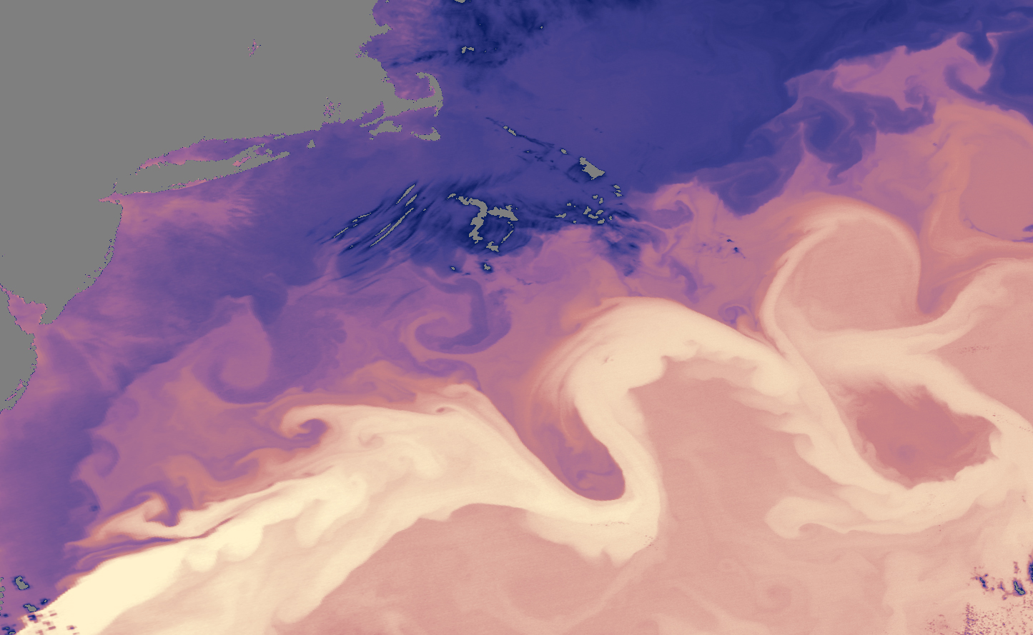
The Gulf Stream becomes particularly fast near the coast of North America. It forms part of the wind-driven circulation of the North Atlantic, with additional contributions from the Florida Current, and then flows northeast into the open ocean. It sheds rotating eddies that can trap warm or cold water, move nutrients and create sharp temperature contrasts. Its extension helps carry ocean heat toward higher latitudes, although the precise movement of heat also depends on other branches of Atlantic circulation.
Think of a large conveyor system with several motors rather than one belt. Winds push the surface, Earth's rotation changes the direction of motion, density differences move water at depth and coastlines guide some flows. The resulting Atlantic circulation involves the Gulf Stream, currents flowing toward subpolar seas, sinking and mixing at higher latitudes, and deep southward movement. A change to one component does not automatically reveal what every other component is doing.
How sunlight becomes atmospheric energy
The tropics receive abundant solar energy, while high latitudes experience larger seasonal contrasts and generally absorb less energy annually. Oceans store part of the energy they receive and release it slowly. Warm water evaporates, adding moisture to the atmosphere, and transfers sensible heat directly to the air. When vapor condenses in clouds, it releases latent heat. Weather systems can tap into these differences in temperature and moisture, although circulation in the atmosphere remains a major driver in its own right.
A familiar experiment is to compare a breeze crossing a warm lake with one crossing a cold field. Air approaching the two surfaces may start alike and leave with different temperatures and humidity. On the Atlantic scale, the same basic physics operates with far more complicated feedbacks. The Gulf Stream creates a corridor of warm sea-surface temperatures beside cooler water. Storms traveling over the region can encounter abrupt differences in the heat and moisture supplied from below.
This does not mean that a warm current automatically produces a stronger storm. Storm development also depends on upper-level winds, pressure systems, atmospheric stability and the storm's path. A current sets part of the stage, not the entire script. Scientists combine ocean and atmosphere measurements precisely because the effects are interactive: weather pushes the ocean, the ocean returns heat and moisture, and later weather develops over water already changed by earlier conditions.

Why one ocean current is not the whole AMOC
The Atlantic Meridional Overturning Circulation is a large-scale pattern of water movement involving northward transport in the upper Atlantic and compensating southward movement at depth. Its name emphasizes movement across latitudes and the vertical exchange between layers. The Gulf Stream belongs to the upper-ocean story, but its flow is strongly affected by winds and the shape of the basin. It is possible for the speed or structure of the Gulf Stream to change without the AMOC changing in exactly the same direction or amount.
Some explanations reduce the AMOC to a picture of salty water sinking beside Greenland. Cooling and salinity do matter because they alter density, and dense waters form in high-latitude regions. But the complete circulation also involves winds, mixing, the Southern Ocean and complicated pathways connecting different water masses. A giant turntable turning on one northern switch is a convenient image, not a faithful model. Scientists use numerical models and instruments across the Atlantic to see how the pieces work together.
That complexity matters when interpreting research. A stronger measured surface current over a decade does not prove that the overturning circulation is strengthening. Likewise, evidence of lower overturning transport does not mean the Gulf Stream has vanished. NOAA's 2026 Gulf Stream findings highlight changes in a particular observed current and period; studies of the AMOC examine a broader three-dimensional system, sometimes over different periods and with different methods. Both results can be scientifically useful without answering the same question.
What was actually discovered recently?
In September 2026, NOAA's Atlantic Oceanographic and Meteorological Laboratory described research using satellite data that found rapid intensification in the Gulf Stream over 2014–2023. Satellites detect properties such as sea-surface height, and researchers can use related measurements to infer features of ocean motion. This gives scientists a wider view than would be possible from ships alone. The finding concerns a defined recent period; it should not be converted into a claim that the Gulf Stream will accelerate indefinitely.
Another NOAA analysis, reported in January 2025, described evidence that pronounced AMOC weakening in the 2000s had paused since the early 2010s. The researchers discussed competing natural and human-driven influences. That pause does not cancel future projections or settle whether a long-term weakening has already become clearly distinguishable from natural variability. Long records are needed because ocean circulation varies from season to season and over many years. A snapshot can look dramatic while still representing one chapter of a longer pattern.
The surprising discovery is therefore about measurement as much as movement. An ocean described in schoolbook diagrams as a tidy loop is behaving like a changing network with overlapping signals. Satellite measurements, direct current observations and computer models can tell partly different stories because each sees a different aspect. The challenge is not choosing the most exciting headline. It is identifying what was measured, for how long, and what those numbers actually allow us to conclude.
How researchers watch a moving ocean
Directly measuring a circulation system is more difficult than observing a river flowing through a narrow channel. The Atlantic is wide, currents move at different depths and a sensor may record only the water immediately around it. The RAPID observing array, deployed near 26.5 degrees north beginning in 2004, uses instruments and related observations across the basin to estimate components of the overturning flow. It has produced a valuable multidecade record of variations that earlier oceanographers could only approximate with isolated surveys.
Researchers also use Argo profiling floats, which descend, drift and return to the surface to transmit temperature and salinity measurements. Satellites reveal ocean-surface height patterns and sea-surface temperatures. Ships provide detailed profiles; moorings measure local currents and water properties for extended periods. Each tool has strengths and gaps. A satellite can survey broad regions but cannot directly photograph the whole deep overturning circulation. A mooring can record changes at one location yet cannot explain the entire ocean by itself.
The instruments become most powerful when interpreted together. From temperature and salinity, oceanographers estimate density; from observed pressure and sea-level differences, they estimate aspects of current motion. Models then help connect sparse measurements, assess competing explanations and test what might happen under altered freshwater, wind or heat inputs. The methods carry uncertainty, which is why reported estimates may change when a record is extended or a calculation improved. Revision is evidence of careful measurement, not automatically evidence of an unreliable science.


The weather connection starts at the sea surface
Some of the clearest links between ocean currents and weather come from the boundaries between warm and cool water. Such temperature fronts can affect where air rises, where clouds form and how storm tracks evolve. Ocean eddies also matter locally: a warm rotating ring may help sustain heat exchange beneath passing weather, while a cold feature can reduce the heat available. The direction and size of an effect depend on season, atmospheric conditions and the location of the ocean feature.
Forecast centers therefore pay attention to sea-surface temperatures when modeling tropical and extratropical weather. Ocean conditions are one input in a coupled forecast system, not a magical advance warning of every storm. A storm can quickly cool the water beneath it through mixing. Later storms encounter the changed surface. A good model must follow the back-and-forth rather than assume the ocean is a passive, unchanging heat reservoir.
For people living far from the Gulf Stream, its influence is usually indirect. An altered pattern of Atlantic heat can affect broad temperature gradients and atmospheric circulation, which in turn may change seasonal rainfall odds. But a single rainstorm in a city could have many immediate causes. Claims that one ocean current caused yesterday's heatwave should be treated cautiously unless a specific attribution study supports them. Climate statistics describe changing probabilities; a local weather forecast describes a particular set of days.
What a weakening AMOC could change
Climate models generally project that the AMOC will weaken in a warming world. As surface waters warm and freshwater inputs alter density, processes contributing to deep-water formation can change. The Intergovernmental Panel on Climate Change assessed that a weakening over the twenty-first century is very likely under all emissions scenarios, while expressing much less confidence about the exact magnitude. A projected slowdown is not the same assertion as an abrupt collapse at a known date.
A weaker AMOC would redistribute heat in the Atlantic and could change regional temperature and precipitation patterns. Potential consequences discussed in scientific assessments include changes in the tropical rain belt, effects on monsoons, shifts in European climate conditions and regional sea-level changes along Atlantic coasts. Those effects would unfold alongside global warming, which continues to influence temperatures. Saying that one region might warm less than it otherwise would is not a prediction that the planet as a whole will cool.
Scientists study the possibility of a more abrupt transition because consequences could be large. The IPCC's Sixth Assessment Report expressed medium confidence that an abrupt collapse would not occur before 2100; that is neither a guarantee of safety nor proof that collapse is imminent. New studies may refine probabilities and mechanisms, and models can disagree. Responsible reporting must present such uncertainty rather than turn an uncertain risk into a calendar date for catastrophe.
Why coastal sea level enters the picture
When people hear about sea-level rise, they often imagine the ocean gaining water evenly everywhere. In reality, regional sea level also responds to currents, winds, changes in water density and the shape of coastlines. Moving currents create pressure patterns and small slopes at the sea surface. If circulation changes, some of those slopes can change too. This is one reason scientists investigate how Atlantic circulation affects sea level along portions of the eastern coast of North America.
A change in regional sea level is not the same as a new global mean. Land movement, tides, storm surge and long-term ice loss also influence what a tide gauge records. A coastal town may experience combined pressures from global ocean expansion, local subsidence and circulation changes, while another town experiences a different combination. For practical planning, the relevant question is how many processes interact at a particular shoreline, not whether one famous current can explain everything.
For coastal infrastructure, even relatively small differences in background sea level can matter when a storm arrives. Higher water allows storm-driven flooding to reach farther inland or more frequently cross a threshold. Yet it would be misleading to attribute a specific flood to the AMOC without analysis. The value of ocean monitoring lies in improving long-term risk estimates alongside other environmental information used by engineers and communities.
The wider consequences for marine life
Currents carry more than warm water. They also move nutrients, oxygen, plankton and the early life stages of fish and other marine animals. A shift in current path can move temperature boundaries, change where food is available or alter the routes by which larvae reach suitable habitats. The Gulf Stream and its eddies create a changing patchwork rather than a single uniform biological corridor. Fisheries scientists have to connect physical oceanography with ecological observations to understand such effects.
Temperature changes can alter which species find a region comfortable, while changes in mixing and upwelling can influence productivity. Some effects occur quickly, such as an eddy transporting a patch of water, while others take years as populations respond. Pollution and fishing pressure add further influences. It would be a mistake to announce that a particular species will disappear simply because an Atlantic circulation index has changed. Biological outcomes depend on many interacting conditions.
This is one reason continued observations benefit people who never read a climate paper. Fishers, shipping operators and marine conservation teams need to know where temperature fronts and currents are moving. Better physical measurements help researchers interpret changes in ecosystems without confusing correlation with cause. A current's most important effect on a community may arrive through its food web or economy rather than as a visible change in daily weather.
The problem with the word collapse
Headlines about ocean circulation often use words that suggest a bridge suddenly failing or a machine being switched off. The AMOC, however, is a complex system that can weaken, reorganize and respond differently in different places. Scientists use precise definitions for abrupt transitions and model thresholds. A model result about one metric does not automatically mean every Atlantic current would stop flowing or that all coastal weather would transform overnight.
The distinction between possibility and prediction is essential. A risk can deserve serious research even when its probability is uncertain. It is also possible for sensational coverage to undermine understanding by encouraging people to ignore later, more measured reports. Readers should ask whether a study examined past observations, a future simulation, or a statistical early-warning indicator. Those approaches answer different questions and carry different assumptions.
An effective account of climate risk can be both clear and cautious. It can say that future AMOC weakening is a major scientific concern; that potential changes in rainfall, heat transport and sea level are important; and that the timing and magnitude of more extreme outcomes remain debated. Good explanations do not need to claim the future is perfectly known in order to show why preparation and continued measurement are worthwhile.
What the current means for your forecast
Suppose a weather app predicts rain for Thursday. That forecast depends mainly on atmospheric observations and computer models initialized with current conditions, though the ocean surface may contribute important information. Knowing that the Gulf Stream has changed over a recent decade does not allow anyone to rewrite the local Thursday forecast by hand. The connection appears more clearly in patterns, such as average temperatures, storm tracks and seasonal likelihoods.
A seasonal outlook may account for unusually warm sea surfaces, persistent ocean patterns and large-scale interactions with the atmosphere. But seasonal predictions are expressed as probabilities because uncertainty grows with time and many influences compete. A change in ocean circulation can adjust the odds, not provide a script for every day. This is why climate studies, seasonal outlooks and seven-day forecasts should never be treated as interchangeable products.
For readers, the practical habit is to look for the scale of the claim. Is the story about a current measured over ten years, a modeled century of change, or a local storm tomorrow? Does it distinguish the Gulf Stream from AMOC? Is there an original research paper or institutional assessment behind the dramatic language? These questions help separate a real scientific discovery from an eye-catching but misleading shortcut.
Why this matters beyond the science
Climate adaptation depends on reliable information about the physical world. Ports make decisions that last decades. Coastal communities weigh flood defenses and land-use choices. Farmers and water managers assess changing rainfall risks. Marine businesses adapt to shifts in species and temperature. None of these decisions can be made from one Gulf Stream headline, yet all can benefit when evidence about ocean circulation improves.
There is also a lesson about uncertainty. An uncertain forecast does not mean scientists know nothing, and a confident general conclusion does not mean every detail is settled. We can be confident that the ocean transports enormous amounts of heat while remaining uncertain about how fast a particular part of its circulation will change in coming decades. Responsible public discussion makes room for both statements.
The current that seems to decide our weather is better understood as part of a shared planetary system. It influences the setting in which weather develops, with connections reaching from storm clouds to fish populations and shorelines. Its shifting behavior is worth watching, but not because the sea possesses a secret switch for the sky. The remarkable truth is that moving water, invisible from the beach, helps shape the conditions under which millions of ordinary lives unfold.
Research and further reading
- NOAA Atlantic Oceanographic and Meteorological Laboratory (September 2026), Satellite Data Reveals Gulf Stream Intensification — recent analysis of the surface current.
- NOAA/AOML (2025), Advancing Our Understanding of the AMOC — evidence and limitations in a recent circulation assessment.
- NOAA National Ocean Service, What Is the AMOC? — basic mechanism and climate connections.
- NOAA/AOML, Meridional Overturning Circulation — measurements of ocean heat and water transport.
- IPCC Sixth Assessment Report, Working Group I, Chapter 9 — assessed circulation projections and uncertainty.
- Canada's Changing Climate Report 2026, Chapter 4 — updated assessment of large-scale atmosphere-ocean processes.
- RAPID AMOC Monitoring Project — long-running direct observational program.
The conversation
Post a Comment