Underwater Robotics: The Machines Exploring the Ocean We Barely Know
Imagine descending into the ocean without a window, without sunlight and without any certainty about what lies ahead.
At first, the water is blue. Then it becomes darker. The familiar outlines of the surface disappear, and the pressure outside begins to increase. Eventually, sunlight becomes a memory. Around you are enormous underwater mountains, strange geological formations, animals that produce their own light and ecosystems that exist in conditions once considered almost impossible for life.
No human diver could comfortably explore most of this environment. Even highly trained technical divers face strict limits on depth, time and safety.
But machines can go much further.
Some are controlled by scientists sitting aboard research ships. Others navigate independently through the darkness, following programmed routes while collecting information about the seafloor. Some carry cameras capable of recording extraordinary marine life. Others use sonar to map enormous underwater landscapes, locate shipwrecks or examine industrial infrastructure thousands of metres below the surface.
These machines belong to a rapidly developing field known as underwater robotics.
From remotely operated vehicles to autonomous underwater robots, this technology is changing how humanity investigates the ocean. It is helping scientists discover previously unknown species, understand underwater volcanoes, study fragile ecosystems, inspect offshore energy installations and investigate historical shipwrecks.
The importance of these machines goes beyond exploration. They are becoming essential scientific instruments, industrial inspection systems, environmental monitoring platforms and tools for understanding a planet whose largest physical environment remains surprisingly unfamiliar.
The ocean covers approximately 71% of Earth's surface. Yet much of its seafloor has not been mapped in detail, and enormous portions of the deep ocean have never been directly observed.
Underwater robotics is helping close that gap.
Key Takeaways
- ROVs (Remotely Operated Vehicles) are connected to ships by cables and controlled by human pilots.
- AUVs (Autonomous Underwater Vehicles) navigate underwater independently, following programmed missions and collecting data.
- HROVs (Hybrid Remotely Operated Vehicles) combine autonomous exploration with remote human control.
- Sonar allows underwater robots to map the seafloor even when cameras cannot see anything.
- Robotic arms, sampling equipment and advanced sensors help researchers investigate marine organisms, geological formations and underwater structures.
- Industries use underwater robots to inspect pipelines, offshore platforms, cables and ship hulls without sending divers into dangerous environments.
- Deep-sea robots are revealing previously undocumented habitats, species and geological features.
- The technology still faces major challenges, including extreme pressure, limited battery life, difficult navigation and underwater communication.
- Better ocean maps and robotic observations could improve marine conservation, climate research, maritime safety and scientific understanding.
1. The Ocean Is Still One of Earth's Great Unknowns
We tend to think of Earth as a thoroughly investigated planet. Satellites photograph its continents, aircraft cross its oceans, and digital maps can identify individual streets and buildings.
Yet beneath the waves lies an enormous environment that remains incompletely understood.
The ocean is not simply a flat blue surface covering the gaps between continents. It contains mountain ranges, deep trenches, enormous plains, canyons, underwater volcanoes, hydrothermal vents and ecosystems that operate under conditions very different from those found on land.
The average ocean depth is approximately 3,682 metres. Some trenches descend far deeper, reaching depths where the pressure would destroy ordinary equipment almost instantly.
Even the basic geography of the seabed remains incomplete.
According to NOAA's June 2025 figures, only 27.3% of the global seafloor had been mapped using modern, high-resolution technology. Satellite measurements provide broad estimates of the entire seafloor, but they cannot reveal the same detail as direct sonar surveys conducted close to the bottom.
This distinction matters. Having a rough estimate of the shape of an underwater mountain is not the same as knowing its slopes, individual geological formations, coral communities or surrounding habitats.
It is similar to looking at a country on a map from an airplane. You can identify its mountains and coastlines, but you cannot see every road, building, river or neighbourhood.
Underwater robots help scientists move from the broad picture to the details.
Why humans cannot simply explore everything themselves
Human divers have explored remarkable underwater environments, but diving becomes increasingly difficult with depth.
Pressure rises by approximately one atmosphere for every additional ten metres of seawater. At 1,000 metres, the surrounding pressure is roughly 100 times atmospheric pressure at sea level. At 6,000 metres, it approaches 600 atmospheres.
There are also problems beyond pressure:
- Natural sunlight disappears with depth.
- Water temperatures become extremely cold.
- Human breathing systems require complex life support.
- Decompression and limited underwater endurance restrict diving operations.
- Strong currents, unstable terrain and entanglement hazards create additional risks.
A robotic vehicle does not need food, oxygen or a human-sized pressure cabin. Its electronics and mechanical components still require sophisticated protection, but engineers can design a compact machine specifically for the environment it will encounter.
That makes underwater robotics one of the most important technologies in modern ocean science.
2. What Exactly Is Underwater Robotics?
Underwater robotics is the engineering field concerned with machines designed to operate beneath the water's surface.
These machines may move through the water, hover above the seabed, crawl across underwater structures or remain in a fixed location while collecting information.
They are equipped with different combinations of:
- Cameras and lighting systems.
- Sonar and acoustic sensors.
- Navigation instruments.
- Pressure and temperature sensors.
- Water-sampling equipment.
- Robotic manipulator arms.
- Scientific instruments.
- Onboard computers and data storage.
Not every underwater robot looks like a submarine.
Some resemble yellow torpedoes. Others look like compact mechanical frames covered in cameras, lights and thrusters. Certain vehicles are designed to follow marine animals, while others are built to perform highly precise industrial inspections.
The central idea is simple: send a machine into an environment that is difficult or dangerous for people, collect useful information, and bring that information back to researchers or operators.
Three major categories dominate this field: ROVs, AUVs and hybrid underwater vehicles.
3. ROVs: The Underwater Robots Controlled by Humans

A remotely operated vehicle, commonly called an ROV, is an underwater robot controlled by people from a ship or another surface platform.
The simplest way to imagine an ROV is as an underwater machine connected to a pilot through a long electronic lifeline.
The connection is called a tether or umbilical cable.
It carries control signals from the surface to the vehicle and sends information back, including video, instrument readings and operational data.
An operator can use joysticks, computer screens and specialist controls to move the vehicle through the water.
This arrangement gives the pilot something extremely valuable: direct control over what the machine does next.
If a scientist sees an unusual animal, the ROV can slow down, turn towards it and record a closer view. If a geological formation appears interesting, the pilot can position the vehicle above it and collect a sample.
NOAA explains that ROVs are used for both scientific exploration and industrial applications, including underwater pipeline inspections and offshore platform work.
How an ROV works
Most deep-sea ROV systems combine several important components.
1. The vehicle frame
The frame holds the equipment together. It is designed to withstand underwater forces while providing mounting points for cameras, lights, sensors and tools.
2. Thrusters
Electric or hydraulic thrusters move the ROV in different directions. Multiple thrusters allow it to move forward, backwards, sideways and vertically.
This is important because deep-sea exploration often requires precision rather than speed.
An ROV may need to hover just above a fragile coral formation without touching it.
3. Cameras
High-definition cameras provide the pilot and scientists with visual information. Some vehicles have multiple cameras offering different viewing angles.
4. Lighting
Powerful LED lights illuminate the surrounding water. Without artificial lighting, cameras would have almost nothing to record at great depths.
5. Manipulator arms
Robotic arms allow the vehicle to interact with objects. Depending on their design, they can collect biological specimens, pick up geological samples, operate equipment or perform delicate tasks.
6. Sensors
Sensors measure conditions such as temperature, depth, salinity, dissolved oxygen and water clarity.
7. The tether
The tether connects the ROV to its control system aboard the ship. On many systems, it also provides electrical power.
This combination makes the ROV more than an underwater camera. It becomes a remotely controlled scientific laboratory.
Why the tether matters
The cable is one of the ROV's greatest advantages and one of its biggest limitations.
It allows operators to control the machine continuously and receive live video. However, it can become tangled, caught on obstacles or difficult to manage when the vehicle travels across complicated terrain.
The surface ship must also manage the cable as it lowers and recovers the vehicle.
This is why ROV operations involve much more than simply putting a robot into the sea. Pilots, engineers, deck crews and scientists must coordinate carefully.
Deep Discoverer: A real example
One of the best-known scientific ROVs is Deep Discoverer, operated by NOAA Ocean Exploration.
It works with a companion vehicle called Seirios and can reach depths of approximately 6,000 metres.
Deep Discoverer carries high-definition cameras, 28 LED lights, two manipulator arms, scientific sensors and equipment for collecting biological, geological and water samples.
Its primary camera can zoom in on an organism only about 7.6 centimetres long from approximately three metres away.
This ability allows scientists to study small animals and geological details that would be difficult to identify using a distant camera.
ROVs such as Deep Discoverer have transformed ocean exploration by allowing scientists to investigate the seafloor while remaining safely aboard a ship.
4. AUVs: Underwater Robots That Explore on Their Own
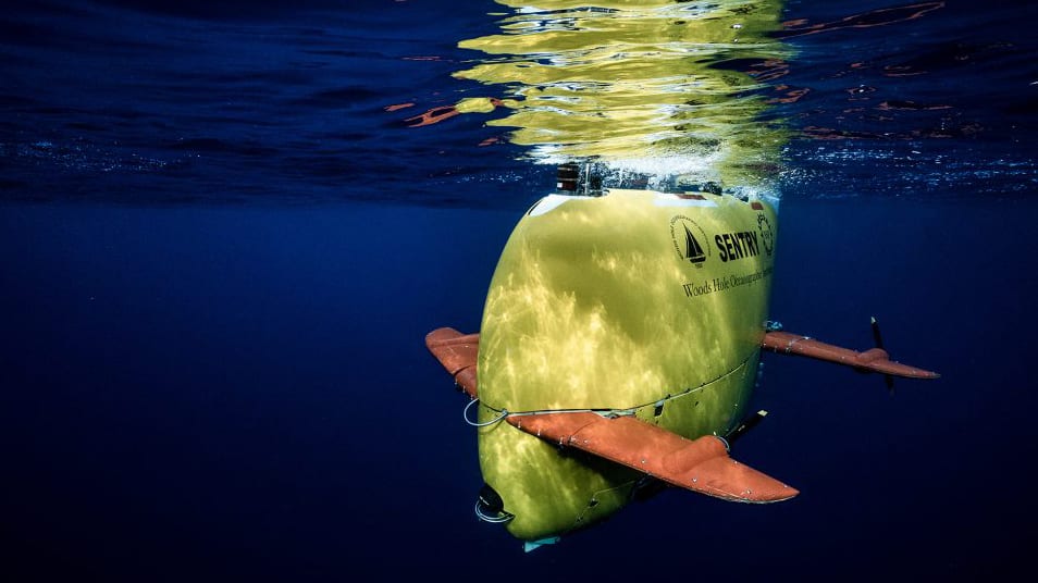
An autonomous underwater vehicle, or AUV, is designed to carry out underwater missions without continuous human control.
Unlike an ROV, an AUV normally has no physical cable connecting it to the research ship.
Instead, engineers program its mission before deployment. The vehicle receives instructions about where to travel, how deep to operate, what data to collect and where to return.
Once launched, its onboard computer manages navigation and movement.
Think of an AUV as an underwater research aircraft. An aircraft follows a flight plan through the atmosphere; an AUV follows a mission plan through the ocean.
The difference is that an underwater vehicle cannot simply use GPS to determine its position.
GPS signals do not penetrate seawater effectively, so AUVs require alternative navigation technologies.
How autonomous underwater vehicles navigate
AUVs combine several technologies to estimate their position and movement.
Inertial navigation systems (INS) use accelerometers and gyroscopes to calculate changes in movement and orientation.
Doppler Velocity Logs (DVLs) send acoustic signals towards the seabed or surrounding water and use the returning signals to estimate the vehicle's speed relative to its environment.
Acoustic positioning systems use underwater sound signals exchanged between the vehicle and reference transponders to help establish its location.
Depth sensors measure pressure to estimate how far beneath the surface the vehicle is travelling.
By combining these measurements, the vehicle can follow a planned route and build a record of where its observations were collected.
Navigation errors can accumulate over time, however, so researchers often use additional positioning methods and correct the vehicle's estimated location after recovering it.
Sentry: A robot that maps the deep ocean
One important example is Sentry, developed at Woods Hole Oceanographic Institution.
Sentry is designed for deep-sea surveys and can operate at depths of approximately 6,000 metres.
It carries instruments including cameras and multibeam sonar, allowing it to collect detailed information about the seafloor.
Rather than simply travelling across the ocean, Sentry can fly relatively close to the bottom, following a carefully planned survey pattern.
This position is important because sonar generally produces more detailed images when the instrument is closer to the surface it is measuring.
AUVs are especially useful when scientists need to survey large areas or repeat the same measurements over time.
They can cover areas that would be difficult to inspect manually, while allowing research vessels to carry out other activities.
What happens when an AUV finishes its mission?
Most conventional AUVs store their scientific information onboard.
When the mission ends, the vehicle returns to a designated recovery location or surfaces so that a research ship can retrieve it.
Scientists then download the collected information, inspect the vehicle and prepare the data for analysis.
Some newer systems can transmit limited information acoustically while underwater, but this is not equivalent to a continuous high-definition video connection.
The distinction between collecting data and transmitting it is important. An AUV may record an extraordinary discovery without anyone aboard the ship seeing it until the vehicle has been recovered.
5. Hybrid Underwater Robots: Combining Human Control and Autonomy
What if a robot could operate independently but still allow a human to take control when necessary?
That is the idea behind hybrid remotely operated vehicles, often called HROVs.
These systems combine features of ROVs and AUVs.
They may begin a mission autonomously, following a planned route and collecting sonar data. If scientists identify something interesting, the vehicle can switch to a remotely operated mode, allowing a pilot to examine the target more closely.
This approach offers several advantages:
- Autonomous operation reduces the need for a long, heavy tether during broad surveys.
- Remote control allows human operators to investigate unexpected discoveries.
- Hybrid systems can carry cameras, sonar instruments and sampling equipment.
- They can combine wide-area mapping with detailed inspection.
A particularly interesting example is the Nereid Under Ice, developed by Woods Hole Oceanographic Institution.
It was designed to investigate environments beneath sea ice, where conventional tethered systems can face serious operational challenges.
Another example is the Saab Sabertooth hybrid AUV/ROV, which has been used in underwater archaeological investigations.
NOAA's Wisconsin Shipwreck Coast project used a Sabertooth hybrid vehicle during fieldwork in 2025 and 2026 to document historically significant shipwrecks in Lake Michigan. The project combined robotic vehicle operations and sonar to collect more detailed information about the wrecks.
Hybrid technology is particularly valuable when researchers cannot predict exactly what they will encounter.
A machine can travel independently across a large area, then become a remotely controlled inspection tool when something deserves closer attention.
6. How Underwater Robots Map the Ocean Floor
One of the most important jobs performed by underwater robots is creating detailed maps of the seafloor.
This process is known as bathymetric mapping.
On land, satellites, aircraft and survey equipment can measure the height of mountains, valleys and hills. Beneath the ocean, scientists need different tools because ordinary cameras cannot reveal the shape of the bottom across large distances.
The solution is sound.
Sonar: Seeing underwater with sound
Sonar stands for Sound Navigation and Ranging.
It works by transmitting sound waves and measuring how long they take to return after hitting an object or the seabed.
Because sound travels through water much more effectively than light, sonar is one of the most valuable technologies in ocean exploration.
Imagine shouting inside a large empty building and listening for the echo. The delay between your voice and its return provides information about the distance to a wall.
Sonar uses a similar principle, but with carefully controlled acoustic signals and highly accurate timing.
Different sonar systems provide different types of information.
Multibeam sonar
Multibeam sonar sends out multiple sound beams across a wide area beneath a ship or underwater vehicle.
By measuring the returning signals, computers can calculate the depth of many points on the seafloor.
The result is a detailed representation of underwater terrain.
Researchers can identify:
- Underwater mountains and ridges.
- Deep canyons and trenches.
- Volcanic formations.
- Seafloor depressions.
- Potential geological hazards.
- Features that may provide habitats for marine life.
Side-scan sonar
Side-scan sonar creates images based on the strength of sound reflections from the seafloor.
It is especially useful for identifying objects and changes in the texture of the bottom.
A shipwreck, for example, may produce a distinctive acoustic shadow that makes it easier to identify against surrounding sediment.
Sub-bottom profiling
Some instruments send lower-frequency sound into the seabed and analyse the returning signals.
These systems can reveal layers of sediment and geological structures beneath the ocean floor.
This is valuable for studying geological history, sediment movement and the structure of underwater environments.
MBARI's seafloor-mapping AUVs combine multibeam sonar, side-scan sonar and sub-bottom profiling. Its systems are designed to produce detailed maps at depths of up to 6,000 metres.
Why underwater maps matter
A detailed map is not simply an attractive scientific image.
It helps researchers decide where to deploy ROVs, identify possible geological features and locate areas that deserve further investigation.
It can also support marine conservation by revealing habitats that might otherwise remain undocumented.
For example, a sonar survey may identify an underwater mountain with unusual geological characteristics. Scientists can then send an ROV to investigate whether the mountain supports deep-sea corals, sponges or other organisms.
The mapping vehicle identifies the landscape. The inspection vehicle helps explain what lives there.
Together, they provide a much more complete picture.
7. Studying Marine Life Without Disturbing It
Underwater robots are not only interested in rocks, mountains and geological formations.
They are also becoming increasingly important tools for marine biology.
The ocean contains organisms that are difficult to observe using conventional diving equipment. Some live at great depths, others are extremely small, and certain animals are fragile enough that approaching them with a large vehicle can disturb their natural behaviour.
Robotic systems are helping scientists overcome these problems.
Cameras reveal previously unseen behaviour
High-resolution cameras allow researchers to observe marine animals in their natural environment.
Scientists can record feeding, movement, interactions between species and responses to environmental changes.
The footage can then be analysed repeatedly, allowing researchers to study behaviour that may have been missed during a short human observation.
Some deep-sea animals also produce their own light through bioluminescence.
Cameras with appropriate sensitivity can document these displays, providing information about communication, defence and feeding strategies.
Environmental DNA: Finding life without seeing it
One of the most interesting developments is the use of environmental DNA, or eDNA.
Animals release genetic material into their surroundings through skin cells, mucus, waste and other biological material.
By collecting seawater and filtering it, researchers can sometimes detect traces of DNA left behind by organisms.
This means scientists may identify the presence of species even when they never appear in a camera recording.
It is similar to finding fingerprints at a location without seeing the person who left them.
eDNA does not automatically reveal how many animals are present or exactly where they are located. DNA can travel through currents, degrade over time and originate from organisms that have moved away.
Nevertheless, it provides an additional source of information that complements cameras and traditional biological sampling.
Mesobot: Following fragile animals in the twilight zone
One particularly fascinating project is Mesobot, developed through collaboration involving Woods Hole Oceanographic Institution, MBARI, Stanford University and the University of Texas Rio Grande Valley.
Mesobot was designed to study the ocean's twilight zone, generally associated with depths of approximately 200 to 1,000 metres.
This region contains gelatinous animals, zooplankton and other organisms that can be difficult to observe without disturbing them.
Mesobot can operate autonomously or through a lightweight tether. Its slow-moving propulsion system and carefully designed lighting help it follow animals while minimising disturbance.
It can also carry equipment that collects environmental DNA samples.
The goal is not simply to photograph an animal but to understand how it moves, feeds and interacts with the surrounding environment.
CUREE: Finding biodiversity hotspots on coral reefs
A newer example emerged in May 2026.
Researchers at Woods Hole Oceanographic Institution reported work using an autonomous underwater robot called CUREE, short for Curious Underwater Robot for Ecosystem Exploration.
The system combines cameras, hydrophones and onboard computing to examine coral reef environments.
It uses both visual and acoustic information to identify areas with concentrated biological activity.
During field trials in the U.S. Virgin Islands, researchers repeatedly identified a biodiversity hotspot around a large pillar coral structure. Fish densities near that feature were nearly 25 times higher than in other parts of the surveyed reef.
The result illustrates an important change in underwater robotics: some machines are no longer just following routes. They can use information from their surroundings to help decide where scientific attention should be directed.
8. Inspecting Pipelines, Offshore Platforms and Underwater Infrastructure
Not every underwater robot is built for scientific discovery.
A substantial part of underwater robotics supports industries that depend on equipment operating beneath the sea.
Oil and gas installations, offshore wind farms, telecommunications cables and subsea pipelines require regular inspection.
These structures can be located in deep water, where sending divers is expensive, complicated or unsafe.
Robots provide a practical alternative.
Pipeline inspection
Subsea pipelines transport oil, gas and other materials between offshore facilities and coastal infrastructure.
They can extend over long distances and operate under challenging environmental conditions.
Over time, they may experience corrosion, physical damage, sediment movement, changes in support conditions or problems with connections.
An inspection ROV can travel along a pipeline while recording video and sonar information.
Its sensors can help identify:
- Visible external damage.
- Corrosion and deterioration.
- Unexpected movement.
- Exposed or unsupported sections.
- Objects resting against the pipeline.
- Problems around joints and connections.
More advanced systems can use sonar and computer vision to identify features automatically.
The rise of robotic manipulation
Some underwater robots are beginning to perform tasks that previously required more direct human intervention.
In February 2026, a research project documented by the US Bureau of Safety and Environmental Enforcement reported a robotic smart-touch system for subsea pipeline connections.
The system used an ROV with sonar, machine vision, robotic gripping and vibration-based sensing to locate and assess bolted pipeline flanges.
Its purpose was to evaluate bolt tightness and reduce the need for diver intervention.
The project demonstrated an end-to-end autonomous inspection process, although this should not be confused with the claim that all subsea infrastructure can now be inspected without human supervision.
Offshore wind farms and renewable energy
Offshore wind installations also depend on underwater infrastructure.
Their foundations, connecting cables and other subsea components must be inspected to detect potential damage and changes in the surrounding seabed.
Underwater robots can help survey these installations and monitor their condition.
As offshore renewable energy expands, the demand for reliable underwater inspection technology is likely to grow.
Why companies use robots
The main advantages are safety, access and repeatability.
A robot can inspect a structure without requiring a diver to spend time in a dangerous environment. It can also collect comparable information during repeated inspections, making it easier to identify changes over months or years.
However, robots do not eliminate every operational risk. They still require trained personnel, reliable equipment, suitable weather and careful planning.
9. Discovering Shipwrecks and Preserving Underwater History
The ocean floor is also an enormous historical archive.
Thousands of ships have sunk through accidents, storms, conflict and other events. Some wrecks are well documented, while others remain undiscovered.
Underwater robots are changing maritime archaeology by allowing researchers to locate, examine and document these sites in remarkable detail.
Finding wrecks with sonar
AUVs and sonar-equipped survey systems can scan large areas of seabed.
They search for unusual shapes, acoustic shadows and objects that differ from the surrounding terrain.
Once a possible wreck is located, an ROV can investigate it using cameras and specialised instruments.
Researchers can identify structural details, examine the condition of the vessel and record its position.
Building three-dimensional models
One important technique is photogrammetry.
This process uses overlapping photographs taken from different angles to reconstruct a three-dimensional model of an object or location.
An underwater robot can follow a planned route around a wreck, collecting hundreds or thousands of photographs.
Specialist software then identifies common features across the images and combines them into a detailed digital model.
The resulting reconstruction can help archaeologists examine a shipwreck without repeatedly disturbing the physical site.
NOAA explains that photogrammetry is increasingly valuable for documenting underwater archaeological locations and preserving detailed records of sites that may deteriorate over time.
A digital record of the past
Three-dimensional models can reveal details that might be difficult to understand from individual photographs.
Researchers can examine the position of debris, identify structural damage and compare the condition of a wreck across different surveys.
These records also have educational value.
Museums, researchers and members of the public can explore digital representations of underwater heritage without physically visiting fragile sites.
Underwater robotics is therefore helping preserve history as well as discover it.
10. What Are These Robots Revealing About the Deep Ocean?
Every successful robotic expedition adds another piece to the picture of an environment that scientists are still learning to understand.
Some discoveries are geological. Others involve unfamiliar animals, unusual habitats or biological processes that influence the wider planet.
Hydrothermal vents: Ecosystems powered by chemistry
Hydrothermal vents are among the most extraordinary environments discovered on the seafloor.
They form when seawater enters cracks in the ocean crust, becomes heated by geological activity and returns through openings in the seabed.
The resulting fluids can contain dissolved minerals and chemical compounds.
Around some vents, researchers find communities of organisms that depend on chemical energy rather than sunlight.
This is known as chemosynthesis.
Instead of relying directly on sunlight to produce energy, certain microorganisms use chemical reactions involving compounds such as hydrogen sulfide to support biological production.
These microorganisms can form the foundation of ecosystems containing specialised worms, mussels, crabs and other animals.
ROVs are particularly valuable here because they can approach these environments, photograph their inhabitants and collect samples without exposing human divers to extreme conditions.
They can also measure water temperature and collect fluid samples for chemical analysis.
Cold seeps: Life around chemicals escaping from the seabed
Cold seeps are another important discovery.
They occur where methane, hydrogen sulfide and other substances escape naturally from sediments beneath the ocean.
Despite the name, the word cold does not necessarily mean that the surrounding water is unusually cold. It distinguishes these environments from hot hydrothermal systems.
Cold seeps can support specialised biological communities, including organisms that depend on microbial processes.
Robotic surveys help scientists identify these habitats, study their geological structure and examine how organisms interact with their surroundings.
Seamounts: Underwater mountains with hidden ecosystems
Seamounts are mountains rising from the ocean floor without reaching the sea surface.
Some are volcanic in origin, while others have more complicated geological histories.
They can influence ocean currents and create conditions that support concentrated marine life.
Deep-sea corals and sponges may grow on their rocky surfaces, creating habitats for other organisms.
The problem is that a seamount may be thousands of metres beneath the surface and far from any coastline.
A research ship can use sonar to identify its general shape, but an ROV or AUV is often needed to investigate its detailed structure.
In 2025, NOAA's Beyond the Blue expedition used robotic exploration to investigate the Papahānaumokuākea region of the Pacific, including geological features and deep-sea coral communities. Its 2026 ROV Shakedown programme also demonstrated how Deep Discoverer could explore Dutton Seamount around the Hawaiian Islands.
The discovery problem: We cannot identify what we have never seen
An important scientific challenge is that discovering an unfamiliar animal does not immediately mean discovering a new species.
Researchers must collect adequate evidence, compare specimens with existing records and, where appropriate, examine genetic information.
Some organisms may look similar despite being genetically distinct. Others may have unusual appearances but belong to already documented groups.
Robots provide the observations and samples needed for this work, but biological classification still requires careful scientific analysis.
The deep sea is not a mysterious world simply because it looks strange in photographs. It is a complex biological environment whose relationships and processes need to be investigated systematically.
11. The Technology Challenges: Why Exploring Underwater Is So Difficult
Underwater robotics has advanced significantly, but the ocean remains an exceptionally demanding environment for machines.
Engineering a robot that works perfectly in a laboratory is one thing. Making it reliable at several thousand metres below the surface is another.
Extreme pressure
Pressure is probably the most obvious challenge.
At a depth of 6,000 metres, pressure reaches approximately 596 atmospheres.
That is an enormous force acting on every exposed part of a vehicle.
An ordinary electronic enclosure could collapse under these conditions.
Engineers therefore use pressure-resistant housings, specialised materials, careful structural design and extensive pressure testing.
Some equipment uses oil-filled or pressure-compensated designs, allowing components to operate without relying entirely on conventional air-filled housings.
Darkness and visibility
Sunlight does not reach the deep ocean.
Beyond approximately 1,000 metres, there is no natural sunlight.
Robots need powerful artificial lights and sensitive cameras to record their surroundings.
However, bright lighting can create another problem.
Tiny particles suspended in water can reflect the light back into the camera, producing a hazy appearance known as backscatter.
This is why professional underwater imaging systems carefully position lights away from the camera's direct viewing direction.
In certain scientific applications, lighting must also be chosen to avoid disturbing the animals being observed.
Communication is not like communication on land
Underwater robots face a major communications problem.
Radio signals, which allow phones and ordinary wireless devices to communicate, do not travel effectively through seawater.
Acoustic communication is a common alternative.
It allows vehicles to exchange certain information using sound signals.
But acoustic links generally cannot provide the high-bandwidth, low-latency connection required for continuous high-definition video.
This is one reason tethered ROVs remain so useful.
Their cables provide a direct connection to the surface, allowing pilots to control the vehicle and receive video.
AUVs, meanwhile, often store much of their information until they can surface and transmit it.
Battery life and endurance
An autonomous robot must carry enough energy to complete its mission.
It may need to travel several kilometres, operate sonar systems, power navigation instruments, capture images and maintain communication.
All of this consumes energy.
Larger batteries increase endurance but also add weight, volume and engineering complexity.
Researchers are investigating improved battery technologies, energy-efficient propulsion and smarter mission planning.
Corrosion and mechanical failure
Seawater is highly corrosive to many materials.
Electrical connections, metal frames, seals and moving parts must be protected against saltwater exposure.
Even a small leak can destroy expensive electronics.
The pressure, cold and corrosive environment also place additional demands on maintenance.
A vehicle that completes a successful deep-sea mission may still require substantial inspection and servicing before its next deployment.
Navigation without GPS
An AUV cannot simply connect to GPS when it dives.
It must estimate its position through inertial navigation, acoustic positioning, Doppler measurements and other sensors.
Each system has limitations.
Errors can accumulate, and currents may push the vehicle away from its planned route.
This makes underwater navigation a continuing engineering challenge.
NOAA's overview of deep-ocean technology identifies pressure, temperature, darkness, communication and corrosion among the major obstacles engineers must overcome.
12. Artificial Intelligence and the Next Generation of Ocean Robots
The next major development in underwater robotics may not simply be better cameras or stronger batteries.
It may be the ability of machines to interpret their surroundings and make more useful decisions.
Artificial intelligence is increasingly being applied to underwater data analysis.
A single expedition can produce enormous quantities of photographs, sonar readings, video recordings and sensor measurements.
Reviewing everything manually takes time.
AI systems can help researchers identify patterns, classify objects and prioritise unusual observations.
AI-powered image recognition
Computer vision systems can be trained to identify marine organisms in underwater photographs.
They may help distinguish fish, corals, sponges and other objects, reducing the time required to analyse large image collections.
These systems are not perfect.
Poor lighting, unusual camera angles, blurred images and unfamiliar species can cause mistakes.
Human verification remains important, particularly when observations are used to support scientific conclusions or conservation decisions.
Robots that adapt their missions
Traditional AUVs generally follow instructions prepared before deployment.
More advanced systems can use their sensors and onboard computing to respond to information gathered during a mission.
For example, a robot surveying a reef might detect an area of unusually high biological activity and investigate it more closely.
The CUREE project demonstrates this direction by combining sound, visual observations and onboard decision-making to identify biodiversity hotspots.
Groups of robots working together
Another possibility is using several underwater robots as a coordinated team.
One vehicle could map a large area while another examines specific features.
A third might collect biological samples, while a surface vehicle manages communication and coordinates the mission.
This approach could increase coverage and reduce the time required to investigate complex environments.
However, underwater communication limitations make coordination difficult.
Researchers must develop reliable systems for sharing information, preventing collisions and managing situations in which vehicles lose contact.
Continuous ocean monitoring
Most traditional ocean expeditions provide observations over a limited period.
Robotic systems could help establish longer-term monitoring networks.
For example, underwater robots might repeatedly inspect a coral reef, monitor a subsea installation or record changes around a hydrothermal vent.
Over time, these observations could help scientists identify environmental changes that would be difficult to recognise during a single expedition.
The goal is to move from occasional exploration towards a more continuous understanding of the ocean.
13. Can Underwater Robots Help Protect the Ocean?
Underwater robotics has an important role in environmental science and marine conservation.
The ability to observe ecosystems without repeatedly sending divers into difficult conditions can improve monitoring and research.
Robots can help identify vulnerable habitats, record changes in coral communities and monitor areas affected by human activities.
Monitoring coral reefs
Coral reefs are biologically important ecosystems, but they face pressure from warming water, disease, pollution and other environmental changes.
Autonomous systems can repeatedly survey reef structures and record the distribution of organisms.
Cameras, hydrophones and environmental sensors provide different types of information about reef health.
The CUREE project demonstrates how robotic systems can identify small-scale concentrations of biodiversity, potentially helping conservation teams decide which areas deserve particular attention.
Monitoring pollution
ROVs and AUVs can investigate underwater pollution sources and collect information about environmental conditions.
Depending on their equipment, they may help locate debris, inspect damaged infrastructure or collect water and sediment samples.
They can also monitor areas where industrial activity may affect the seabed.
However, robots do not automatically solve pollution problems. They provide observations that authorities and researchers can use to make better decisions.
Protecting fragile habitats
Some deep-sea habitats are particularly vulnerable to physical disturbance.
Deep-sea corals, for example, can grow slowly and may take a long time to recover from damage.
A robot can observe these habitats without a person physically entering them, but its own movement can still cause disturbance.
Thrusters may stir up sediment, equipment can make contact with organisms, and sampling can remove biological material.
Responsible robotic exploration therefore requires careful operating procedures.
The danger of using technology without understanding its consequences
Better mapping can support conservation, but it can also make previously inaccessible resources easier to locate.
Detailed maps may be useful for scientific research and environmental protection, yet they may also support commercial activities that could disturb sensitive ecosystems.
The development of deep-sea mining, offshore infrastructure and other industrial activities makes this issue particularly important.
The technology itself is not automatically environmentally beneficial or harmful. Its impact depends on how it is designed, operated and governed.
The most valuable future for underwater robotics is one in which exploration produces knowledge that helps society manage marine environments responsibly.
14. What Comes Next for Underwater Robotics?
The next generation of underwater robots will probably become more capable, more autonomous and more specialised.
Several developments are especially important.
- Longer endurance: Better energy storage and efficient propulsion could allow robots to remain underwater for longer missions.
- Improved navigation: More accurate positioning systems will help AUVs follow complicated routes and return to specific locations.
- Smarter manipulation: Robotic arms may become increasingly capable of carrying out delicate tasks, including inspection, sample collection and equipment maintenance.
- Better imaging: Improved cameras, sonar and laser scanning systems could produce more detailed records of underwater environments.
- More advanced AI: Automated analysis could help scientists process large volumes of data and identify unusual features more quickly.
- Collaborative systems: Multiple vehicles could work together, combining wide-area mapping with detailed investigation.
- More accessible exploration: Smaller and less expensive underwater robots could expand research opportunities for universities, conservation groups and smaller organisations.
There is also growing interest in robots capable of exploring extreme environments, including beneath polar ice and in very deep ocean trenches.
Such missions require new engineering solutions, but they could provide information about some of the least-understood environments on Earth.
The future is unlikely to belong to a single type of robot.
ROVs, AUVs, hybrid systems, research ships, satellites and human scientists will continue to work together.
The most successful missions will combine the strengths of each.
Conclusion: Machines Are Opening a Window Into the Deep
For centuries, the deep ocean was an environment that humanity could only investigate indirectly.
We could measure its surface, study currents, lower instruments into the water and examine samples brought back by ships.
But much of the seabed remained hidden.
Underwater robotics is changing that relationship.
ROVs give scientists remotely controlled eyes and hands in environments where humans cannot safely work. AUVs survey large areas independently. Hybrid vehicles combine autonomous movement with direct human control.
Together, these technologies are producing detailed maps, recording unfamiliar animals, identifying geological formations, inspecting underwater infrastructure and preserving historical shipwrecks.
They are also revealing how much remains unknown.
A detailed map is not the same as a complete understanding of an ecosystem. A photograph does not explain every biological relationship. A successful expedition does not mean that an entire region has been explored.
The ocean remains enormously complex, and scientific knowledge will develop gradually through repeated observations, better instruments and careful analysis.
Yet something important has changed.
We no longer have to rely entirely on what can be reached by a human diver or observed from the surface.
We can send machines into darkness, follow their journeys and bring back information from places that once seemed inaccessible.
The ocean is still largely unfamiliar.
But for the first time, we are developing the tools to explore it in unprecedented detail.
Frequently Asked Questions (FAQ)
1. What are underwater robots used for?
Underwater robots are used to explore the ocean, map the seafloor, study marine life, collect scientific samples, inspect pipelines and offshore structures, locate shipwrecks and monitor underwater environments. Their applications include scientific research, industrial maintenance, archaeology, environmental monitoring and maritime safety.
2. What is the difference between an ROV and an AUV?
An ROV is a remotely operated underwater vehicle connected to a surface ship by a tether. A human pilot controls it and receives information through the cable.
An AUV is an autonomous underwater vehicle that operates without a continuous physical connection to the ship. It follows programmed missions and generally stores its data onboard until it can transmit or be recovered.
3. How deep can underwater robots travel?
It depends on their design.
Some small underwater robots are designed for shallow coastal waters, while specialist deep-sea vehicles can reach approximately 6,000 metres. Certain vehicles are designed for the deepest ocean trenches, where pressure approaches extreme levels.
4. How do underwater robots see in complete darkness?
They use artificial lighting and cameras to record their surroundings.
They can also use sonar, which sends sound waves and analyses their reflections. Sonar is especially useful for mapping the seafloor and identifying objects when visibility is poor.
5. Can underwater robots collect samples?
Yes. Many scientific ROVs have robotic manipulator arms, collection containers, suction samplers and water-sampling instruments.
They can collect rocks, sediments, biological specimens and water samples for further scientific analysis.
6. Can underwater robots operate without GPS?
Yes. GPS signals do not travel effectively through seawater, so underwater vehicles use alternative navigation systems.
These include inertial navigation, Doppler Velocity Logs, depth sensors and acoustic positioning systems.
7. Can underwater robots discover new marine species?
They can help scientists discover organisms that have not previously been documented.
Their cameras, sensors and sampling equipment allow researchers to investigate remote habitats. Biological specimens and genetic material can then be examined to determine whether they represent previously unknown species.
However, a robot recording an unfamiliar animal does not automatically establish that it is a new species. Scientific identification requires additional analysis.
8. Will underwater robots eventually replace human divers and submarines?
Not completely.
Robots are better suited to many dangerous, repetitive and deep-water operations, but human divers and crewed submersibles still offer valuable capabilities.
People can make immediate judgements, interpret unusual situations and adapt to unexpected discoveries.
The likely future is a combination of human expertise, autonomous machines and remotely operated systems working together.
Sources and Further Reading
The following scientific and institutional resources provide additional information about underwater robotics, ocean mapping, marine biology and deep-sea exploration.
- NOAA Ocean Exploration – Remotely Operated Vehicles (ROVs)
- NOAA Ocean Exploration – Autonomous Underwater Vehicles
- NOAA – What Is the Difference Between an AUV and an ROV?
- NOAA – Ocean Exploration Technology
- Woods Hole Oceanographic Institution – Sentry Autonomous Underwater Vehicle
- MBARI – Seafloor Mapping AUV
- NOAA – How Much of the Ocean Has Been Explored?
- Woods Hole Oceanographic Institution – Mesobot
- Woods Hole Oceanographic Institution – CUREE and Coral Reef Biodiversity Hotspots (2026)
- NOAA – Photogrammetry and Underwater Archaeology
- NOAA – Wisconsin Shipwreck Coast Exploration Project
- U.S. Bureau of Safety and Environmental Enforcement – Robotic Inspection of Offshore Pipelines (2026)
- NOAA – Seabed 2030 and Global Ocean Mapping
Photo Credits
- Photo 1: Deep Discoverer exploring Dutton Seamount. Image courtesy of NOAA Ocean Exploration, 2026 ROV Shakedown. Original image and credit.
- Photo 2: Sentry autonomous underwater vehicle. Image courtesy of Woods Hole Oceanographic Institution. Original image and information.
The conversation
Post a Comment